Explore Graveyard Fields near Brevard, North Carolina

image

Graveyard Fields Hiking Trails

Under a sky that flickers between brooding clouds and searing sunlight, Graveyard Fields stands as a realm suspended in contrast. This iconic stretch near Brevard, North Carolina, lures adventurers with its rugged beauty and the echo of a name steeped in mystery.

Centuries ago, charred tree stumps—relics of a devastating fire—dotted this valley like unmarked gravestones, leaving an indelible legacy that lives on in its name. Today, the stumps have faded, replaced by a landscape that hums with life: rolling meadows, roaring waterfalls, and thick tangles of rhododendron.

Step onto the trailhead off the Blue Ridge Parkway, where the sharp scent of evergreen mingles with damp earth, drawing you into the rhythm of the wild. The trail dips into a golden meadow framed by distant peaks. In late summer, wild blueberries transform the valley into a forager’s haven. Further on, the terrain shifts—gentle slopes harden into rockier paths, signaling the adventure ahead.

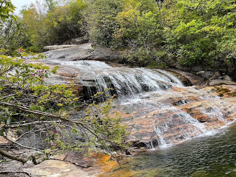
The Lower Falls delivers an early reward, tumbling in sleek ribbons over ancient rock, offering a natural perch to breathe in the mountain stillness. But the call of the upper trail is irresistible, winding upward toward the grandeur of Second Falls. Here, the sound of rushing water greets you long before its mesmerizing cascade comes into view. Along the way, moss-draped boulders and sturdy footbridges weave the path into the timeless fabric of this land.

Whether you come to traverse the loop, gather handfuls of wild berries, or simply revel in the mountain air, Graveyard Fields offers a place to reconnect—with nature, with movement, and with the quiet thrill of discovery. Sturdy boots and a rain jacket are your allies—this land thrives on unpredictability.


Adventure Guide: Hiking Graveyard Fields

Highlights of the Area

  • Lower Falls: Short spur trail to tranquil cascades, ideal for quick rests or family outings.
  • Second Falls: A longer climb rewards you with sweeping mountain vistas and a thunderous waterfall.
  • Blueberry Fields: A haven for berry-picking in late summer and early fall.

Trail Details

  • Distance: 3.3 miles (loop)
  • Difficulty: Moderate (rocky sections and elevation changes)
  • Elevation Gain: Approximately 700 feet

Directions

From Brevard, take US-276 north and merge onto the Blue Ridge Parkway. Follow the Parkway for 7 miles to Graveyard Fields parking (milepost 418.8). Arrive early to secure parking, especially during peak months.

Tips for Hikers

  • Be Prepared: Carry layers for sudden weather shifts and plenty of water.
  • Wildlife Awareness: Keep a respectful distance from any animals and pack out all trash.
  • Navigation: Stick to marked trails to avoid getting lost in dense foliage.

Graveyard Fields isn’t just a hike—it’s an experience, one where every step invites you to marvel at the wild’s unpredictable brilliance.

Adventure Map

Brevard Info

No GPX info

Reviews

Sally Noble3 months ago
Lovely hike directly off the Blue Ridge that ticks all the boxes. Waterfalls, flowers and fields, a little elevation gain but fairly moderate and surrounded by mountains in the valley below. We hiked in late summer so we were fortunate to catch some flowers and early foliage. I imagine springtime would be amazing when the rhododendron are in bloom.
Ron Lamberth3 months ago
It's listed as a 3.2  to 3.5 mile hike. 🤷‍♂️ Well, if you do the hike we did it's probably closer to 4 miles. This is a popular family hike because of its beauty and access to two waterfalls. Hiking to the Lower Falls is fairly easy. This part is considered " the loop". Hiking to the Upper Falls is rather strenuous and is an out and back hike. Your hike starts at steps at the parking lot sidewalk; a wooden sign depicts trail and waterfall locations, but because of intersecting and/or unmarked trails in the area it CAN be confusing at times - especially if you hike to the Upper Falls, so a trail map is generally helpful. This part of the trail is not well marked. The trail of the parking lot is initially paved, which leads to a bridge over Yellowstone Prong, the stream feeding both waterfalls. If going to the Lower Falls (downstream of the bridge, and 0.3 miles from trailhead), cross the bridge, pass a small “off ramp” which the main trail takes to the left, cross the boardwalks, and follow signpost(s). This trail includes a 60-step wooden stairway to the base of the falls. Remember, rocks around waterfalls are very slippery; NEVER go to the top of any waterfall. Blueberries are abundant in the fall. After about a mile, main trail turns left to cross Prong and return, in about a mile, to parking. If going to Upper Falls (1.6 miles from the trailhead), continue straight ahead on the trail, which crosses a small stream and climbs to the falls. (Although Graveyard Fields Trail is rated ``easy' overall, the majority (approximately ½ mile) of this trail has a rougher surface and steeper grade than the majority of the trail.) Length of 3.2 or 3.5 miles assumes proceeding directly to Upper Falls as described and retracing one’s steps to parking. Actually I think the Lower Falls is actually prettier and is less of a hike so - unless you're just wanting more of a workout, just visit this falls. 👍👍👍👍👍
Trix Mensah5 months ago
This is a great hiking area about 30miles out of Asheville on the scenic Blue Ridge Parkway. There are options to do the loop trail (each loop about 0.4/0.3miles) or to hike longer to the Upper Falls and also a section of the MST. If you don't want to hike, you can just cool off in the waters and on the rocks, which is a short walk from parking. This trail is also very dog friendly.
Michael Barber3 months ago
Lovely hiking trail that isn't difficult at all. A bit narrow at times but not dangerous, just close trees and bushes. The Lower falls section is really cool to see when the water is low. Only took us about 40 minutes to hike the lower falls loop section.
Benjamin Sung5 months ago
We didn't hike the loop, just the out and back to the upper falls, but the parking/trailhead are the same for both. Great views at the trailhead, hike is almost entirely shaded by rhododendrons and trees, until you get to the falls. Careful where the rocks are wet, it gets slippery in a hurry. There's a few side trails to the right that will take you to the top of the falls - needs some scrambling, but the view is worth it👍

Related Posts

featured

Courthouse Falls near Brevard: A Hidden Gem for Nature Enthusiasts

featured

Hiking To Cedar Rock Creek Falls in Brevard

featured

Take In The Views at Courthouse Valley Overlook in Brevard

featured

Hiking To Discovery Falls in Brevard