Hiking the Red Rock Trail System in Milton
Hiking the Red Rock Trail System in Milton
The Red Rock Trail System in Milton, Florida, offers an exceptional hiking experience through the Blackwater River State Forest, one of Florida’s most diverse natural landscapes. Known for its distinctive red clay hills, towering longleaf pines, and serene creekside paths, this trail system provides an ideal setting for outdoor enthusiasts seeking a scenic and moderately challenging hike. The combination of rolling terrain, unique flora and fauna, and historic sites makes this hiking destination a must-visit for both locals and visitors.
Adventure Guide to Hiking the Red Rock Trail System
Wiregrass Trail
- Distance: 4.5 miles
- Notable Features: This loop trail winds through a pristine longleaf pine ecosystem, offering opportunities to see wild turkey, gopher tortoises, and red-cockaded woodpeckers. The compacted red clay soil provides solid footing, making it a great option even after light rainfall.
- Local Insight: Named after the native wiregrass, this trail was once part of a historic fire-dependent ecosystem maintained by early settlers.
Juniper Creek Trail
- Distance: 8.5 miles
- Notable Features: Highlights include steep bluffs, views of Juniper Creek, and access to sandy riverbanks. This trail is ideal for hikers looking for a longer trek with varied terrain and rewarding panoramic scenery.
- Local Insight: Sections of this trail pass through lands once used for early turpentine production, reflecting Milton’s rich history in naval stores.
Hutton Unit Trails
- Distance: Various loops from 1.5 to 10 miles
- Notable Features: Ideal for beginners and families, these trails feature gentle elevations, shaded pathways, and access to small creek crossings.
- Local Insight: This area of the forest was historically used for timber farming and now plays a vital role in prescribed fire management to maintain habitat health.
Visitor Tips
- Best Time to Visit: Late fall through early spring offers cooler temperatures and fewer insects.
- What to Bring: Sturdy hiking boots, water, bug repellent, and a trail map.
- Directions: From Navarre Beach, take FL-87 North to Munson Highway (FL-191)—an approximately 40-minute drive.
Adventure Map
Reviews
Cait Weber3 years ago
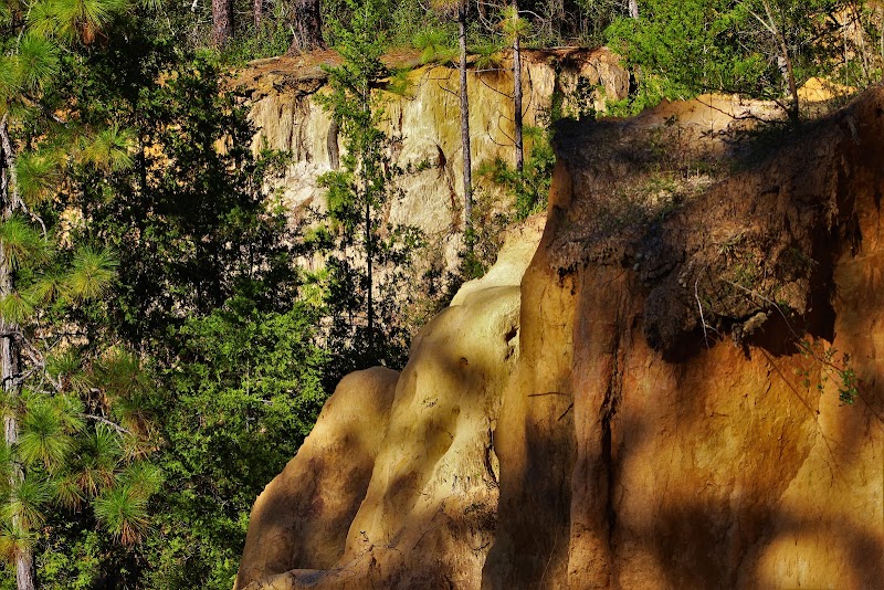
Absolutely beautiful park. I love the hiking trails and appreciate the lack of "stuff", I like seeing nature uninterrupted. I do wish the trails were better marked. There's no wifi once you're there so you're at the mercy of the map. There were trail names that aren't on the map so it's slightly confusing but still absolutely worth it. The red cliffs are absolutely stunning.
Kelly Coberly7 months ago
Great place for hiking and walking, but bring lots of water! The trail is very long, so we usually walk as far as we are comfortable with and then head back. I’ve never gone the full length of it but you’ll get plenty of exercise.
The red cliffs are not far from the main road, so they are pretty easy to get to. You can enter them from the top or the bottom, and walk around them to get to either side.
Many great swimming spots here as well!
Alycia Sherback2 months ago
Loved it! Maintained well with beautiful trees. I’d recommend taking the south trail across the road from the sign since it takes you down to the water and cliffs. There’s even a small parking lot off the side of the road which was helpful
James Monroea month ago
I was searching my area for a good place to day hike with wife and dogs and this place showed in a Google search. This place is an absolute must for anyone who loves to get out for a fairly easy day hike.
Melissa Overkamp Cosgrove2 months ago
Did not expect to see the cliffs. It was so exciting in "flat" Florida!