Hiking the Walls of Jericho Trail in Near Hytop
Hiking the Walls of Jericho Trail in Near Hytop
Introductory Overview
The Walls of Jericho Trail near Hytop, Alabama, is a challenging yet rewarding hike known for its rugged terrain, scenic beauty, and historical significance. This 6.6-mile out-and-back trail descends into a stunning limestone gorge, leading to a breathtaking natural amphitheater with waterfalls and rock formations. With a 1,500-foot elevation change, it requires endurance but offers spectacular views and unspoiled wilderness, making it a top choice for serious hikers.
### Adventure Guide To Hiking the Walls of Jericho Trail
Trailhead and Difficulty Level
- Location: The main trailhead is off Highway 79, about 25 miles south of Winchester, Tennessee.
- Difficulty: Rated strenuous due to the steep descent and ascent, requiring physical preparation. It is recommended for experienced hikers or those comfortable with elevation changes.
- Key Features: Thick forests, river crossings, and a 360-degree panoramic view near the gorge entrance.
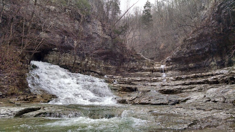
Scenic Highlights at the Bottom
- The Amphitheater: A naturally carved limestone formation where flowing water cascades over rocks, creating multiple waterfalls during wetter months.
- Hidden Caves: Several small cave openings can be spotted near the final section of the trail, adding an element of exploration for adventurers.
- Wildlife Spotting: Frequent sightings of white-tailed deer, salamanders, and turkey vultures along the route.
Crossing Hurricane Creek
- At approximately 2 miles, hikers must cross Hurricane Creek—water levels vary depending on recent rainfall, and waterproof boots are advisable.
- Winter and early spring provide the best waterfall flow, but footing can be slippery.
### Local Insights
- Named the "Grand Canyon of the South", this area was historically used by Indigenous peoples and early settlers for hunting and travel.
- The Nature Conservancy acquired this land for conservation, preserving its ecological significance.
- The area was once used for moonshining operations, with remnants of old structures occasionally visible along the creek.
### Visitor Tips
- Best Time to Visit: Fall and spring offer the most comfortable hiking conditions with vibrant foliage. Avoid summer afternoons, as heat and humidity can be overwhelming.
- What to Bring:
- Sturdy hiking boots (due to rocky inclines).
- 2+ liters of water per person.
- Trekking poles for stability on steep sections.
- Bug repellent and tick protection in warmer months.
- Driving Directions: From Huntsville, Alabama, take US-72 W to AL-65 N, then turn onto Highway 79. Estimated driving time is 1 hour 15 minutes.
Adventure Map
Reviews
William Murphy7 months ago
My son wanted to drive to Alabama and hike some trails. Somehow he found this one. It was cloudy and sprinkling at first. We started off going down, down, down... Look out for the tree roots they will put you on your rear pretty fast. Once you have zigzagged down the poorly marked and maintained trail, you'll cross a bridge and the rain will end and the heat and humidity will hit you hard. After walking a while you'll reach a second bridge. There are a few primitive campsites that are okay. As you keep walking, you'll become soaked in sweat. Then you'll come to a sign that says .5 miles to the Walls of Jericho. That last half mile is about a mile and a half long and it gets treacherous. The rain made everything slippery. The last part of the trail takes you up and down on a very narrow ledge with a steep drop of more than twenty feet with some mean-looking rocks waiting to break your fall. This is a very strenuous adventure and not for small children or people with health concerns.
Going back is grueling as it is up the whole way. The good news is, just when you believe you've made it, there is still another half mile or so of up left.
We were spent when we made it back five hours later. We carried four bottles of water each. We needed eight bottles. It was tough, but we loved it. This trail is probably nothing for an AT Thru Hiker, but for the average weekend hiker it will test you and for us, it was worth the sweat.
Bill from Clewiston
John Macleod10 months ago
It's a 1,000 ft climb going in and out. Beautiful well maintained trails. Very clean. The falls and pools at the end make the trip worth it. Primitive camp grounds throughout the area. There is a couple of caves I saw. Overall it was a very positive experience. I didn't expect this kind of beauty in Alabama. I look forward to seeing what the other parks have in store.
K. T.3 months ago
The other reviews are true concerning the difficulty. The terrain is littered with rocks/stones, tree roots and wet leaves depending on the time of year and weather conditions. The infamous last .5 mile to the "wall" is the most narrow part of the trail and subsequently dangerous in sections. And yeah, the uphill coming back is just that...3 miles mostly uphill.
"How long did it take" is always the question. The answer is it will depend on your pace and fitness level.
It took 4 hours (including a 30 min lunch break at the fall) for our crew of women in their late 40s. We're moderately fit & hike at least once a month. We passed some 20 something year old dudes on the trail who finished in about 2.5 hours. They apparently made it on sheer testerone - no gear, water, etc). We met a group of seniors (60 +) that I'm sure finished in about 6-7 hours. So all that said HYOH, be careful & enjoy.
Robert Frazier4 months ago
The Walls of Jericho is one of my favorite trails to hike in Alabama. It is a difficult hike that can completed in one day. Some people choose to camp at the center point and hike out the next day. Either option can be a fun experience depending on the time you have. The best time of year to hike this trail is spring or early fall to avoid the Alabama heat adding on to the intense elevation gain.
Aliza Brown11 months ago
This is a pretty cool 6.5 mile round trip moderate hike with some beautiful waterfalls at the end! You will descend about 1300 feet into a valley and scramble over a few small rock walls to reach the final waterfall. There are 3 major ones. Do not stop at the large second one after you cross the river. Keep climbing! Well marked trail using red paint on the trees. Completed this hike in March and there were plenty of rocks in the river to avoid getting your shoes wet. Wildflowers were starting to bloom but the trees were still dead. There were a ton of butterflies out. The trailhead is out in the middle of nowhere so there is no gas or food within a 30 min radius. Overall this was a great not too hard hike that rewards you with three stunning waterfalls at the end.