Hike to Laurel Falls in Gatlinburg
image

Hike to Laurel Falls in Gatlinburg

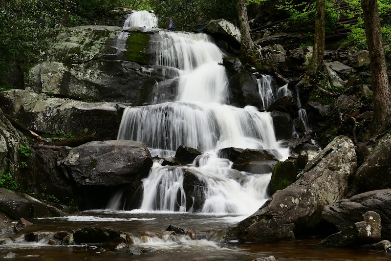
The hike to Laurel Falls is one of the most cherished outdoor activities in the Gatlinburg area, offering visitors a chance to witness one of the most beautiful waterfalls in the Smoky Mountains. This hike is unique not just for its stunning views but also for its accessibility, making it a favorite for families, casual walkers, and serious hikers alike.

Adventure Guide To Hike to Laurel Falls

  • Laurel Falls Trail
    Starting from the Laurel Falls parking area, this 2.6-mile round trip trail features a well-maintained path suitable for all skill levels. What makes it special is its stunning waterfall, cascading 80 feet over rocks. The trail is lined with wildflowers in spring, enhancing the scenic beauty.

  • Scenic Points
    Several designated viewpoints along the trail offer breathtaking vistas of the surrounding landscape. Visitors can pause for photos and truly appreciate the changing colors of the leaves in fall or the lush greenery in summer.

  • Picnic Areas
    Near the trailhead, there are picnic tables and restrooms—ideal for a lunch stop after the hike. This makes it a convenient choice for families wanting to enjoy a full outdoor day.

Local Insights

The Laurel Falls area is steeped in local culture, originally developed by the Civilian Conservation Corps in the 1930s. It holds ecological significance, as the biodiversity around the falls supports various wildlife species. Always remember to leave no trace, ensuring this treasure is preserved.

Visitor Tips

  • Best Times to Visit: Early morning is ideal to avoid crowds, especially in peak seasons (spring and fall).

  • What to Bring:

    • Water and snacks
    • A camera for stunning photos
    • Comfortable hiking shoes to navigate the terrain
  • Driving Directions: From the Smoky Mountains near Gatlinburg, take Little River Road for about 10 minutes to the Laurel Falls Trailhead. Look for a clearly marked parking area.

Hiking to Laurel Falls offers not just physical activity but a chance to connect with the breathtaking nature surrounding Gatlinburg.

Adventure Map

Fighting Creek Gap Road Info

Difficulty

N/A

Distance

N/A

Elevation

N/A ft
Download

Reviews

michelle b3 weeks ago
Beautiful waterfall. My first hike!!
Julie Putnam5 months ago
Wow! Plan ahead, but this is worth the effort! Take water and know there are no restroom spots. The path is uphill almost the whole way, and it is broken up in many sections (so not stroller or wheelchair accessible) - but don’t give up! The waterfall is beautiful, cold, shallow, and easy to access (on the top half), so it is fun to splash in to cool off after the effort to get to the top! It is a great choice to spend a few hours - especially on a hot day! The walk back is downhill and far easier - we loved encouraging folks we passed as we walked down! The park volunteer was encouraging also!
Md Nafiul Alam Nipua year ago
It's a fairly easy hike. The fall was nice. Many people went with their children. Parking near the trail is a mess. Very less spots available. Had to wait for a long time to get parking.
Mallory Powell6 months ago
This hike was a fun, quick hike with a beautiful waterfall at the end. It was paved but some of the trail has broken down and I would not recommend a stroller bigger than a single stroller and even then the trail is a bit rough for one. We saw many black bears and I will warn they are quite conditioned to people. One came right up to the bench at the waterfall looking for food, another was right along the trail and lunged/growled at two men in our groom so stay vigilant and aware on the trail and stick together especially with little ones. I give it four stars just because it was soooo crowded and when I go hiking I like it to be a little more relaxing and less touristy. Also, the parking was insane!!! Not very many spots and you had to wait for one and be quick or someone would steal it from you. You have to pay for a parking voucher at the visitors center.
Bernard Ferrell5 months ago
Beautiful small trail. Bears can be seen. I wish people wouldn't have carved/wrote their names/initials into the rocks. Leave nature as if you were not there so that future generations can see it the way it was supposed to be seen for its natural beauty.

Related Posts

featured

Best Hiking Trails in Ontario for Fall Colors

featured

Carolina Beach State Park

featured

Devils Lake State Park in Wisconsin

featured

Hike the Domingo Baca Trail to TWA Plane Crash Site in Sandia Mountains