Hiking the Tam McArthur Rim Trail in Sisters
image

Hiking the Tam McArthur Rim Trail in Sisters

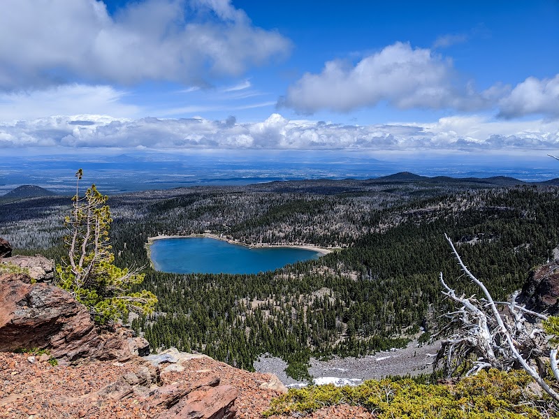
Hiking the Tam McArthur Rim Trail offers outdoor enthusiasts a chance to immerse themselves in the breathtaking landscape surrounding Sisters, Oregon. This trail is known for its stunning panoramic views, diverse flora and fauna, and geological significance, making it a must-visit for both novice and seasoned hikers. Its location near Bend adds to its accessibility, making it a perfect day trip destination.

Adventure Guide To Hiking the Tam McArthur Rim Trail

  • Trailhead Location: The Tam McArthur Rim Trail can be accessed from the Three Creeks Lake area, approximately 30 miles west of Bend. The trailhead is well-marked and features a parking lot that typically accommodates visitors comfortably during peak season.

  • Exceptional Views: One of the standout features of this trail is the breathtaking vista of the Cascade Range, including the majestic Mount Washington and Three Fingered Jack. As hikers ascend, they are treated to views over lush meadows filled with wildflowers in spring and summer, creating vibrant colors against a backdrop of towering peaks.

  • Difficulty Level: This trail is moderate to strenuous, with an elevation gain of around 1,200 feet over a distance of approximately 5.5 miles one way. Proper preparation is key, so ensure you are in good physical condition and familiar with changing weather conditions in the area.

Local Insights

The Tam McArthur Rim Trail boasts a rich historical significance as part of the Deschutes National Forest, an area long cherished by local indigenous tribes for its natural resources. The surrounding environment reflects a unique biodiversity, with opportunities to spot elk, deer, and various bird species along the way.

Visitor Tips

  • Best Times to Visit: The best months to hike are late June through September when the weather is generally stable and the wildflowers are in full bloom.

  • What to Bring:

    • Plenty of water and snacks
    • Sunscreen and hats for sun protection
    • Sturdy hiking boots
    • A camera to capture the stunning scenery
  • Driving Directions: From Bend, take Highway 20 west toward Sisters. Turn onto FS Road 15, which leads to the Three Creeks Lake area. The drive takes about 45 minutes, offering scenic views along the way.

Adventure Map

National Forest Development Road 16 Info

Difficulty

N/A

Distance

N/A

Elevation

N/A ft
Download

Reviews

Timothy Tollsa month ago
Excellent - if you can plan on a full 12 miles of hiking then head up to No Name lake. The views are nonstop incredible between the Tam McArthur Rim view point at ~3 miles and the lake at ~6 miles.
Scott Watts2 years ago
This is one of the most beautiful trails I've hiked. It was a great temp (cool and crisp) with a light dusting of snow. There's something new to see around every curve so you hardly notice how far you've walked. On a clear day you'll get some amazing views of 3 creeks lake and the surrounding landscape towards Sisters and Black Butte. The cliff face at the end of the rim trail offers a panoramic view north. If you have the energy, continue the trail to Broken Hand for amazing views of the Sisters to the north, broken top to the west and Mt. Bachelor to the south. A day well spent! Looking forward to doing it again.
What to do in Southern Oregon4 years ago
What an amazing and gorgeous hike! Get fantastic views of the lakes and mountains in the area. Be prepared for an uphill hike most of the way and eventhough it is June we were caught in a mix of sunshine and snow at times. We were staying in Redmond and didn't quite think that we would be dealing with a 25 degree drop in temperature so layer up. Round-trip 6 miles.
Ron E.2 years ago
This is one our favorite all-time hikes! If you stay in Sisters there is a road that leads directly to the trailhead. You park on the road. You are supposed to get a day pass from recreation.gov for $1. We did but nobody was checking. Same for the parking pass. The hardware store in Sisters said nobody ever gets tickets parked on the road. Once you get up to the top of this trail, keep going for miles! We did 10.5 miles round trip to Broken Hand, with amazing views of Broken top!
Curtis Barnard2 years ago
*Note that this hike requires a NW Forest Pass as well as day-use/overnight limited entry permits during peak season. I did this hike early October and the weather was amazing. Camped at Three Creek Lake the night before which was a bit of a cluster, but worked out well. I kept going past broken hand to the overlook of No Name Lake and Bend Glacier, I HIGHLY recommend that you make the extra effort to go there as the views are out of this world. There is a section maybe 1/4 mile past broken hand where the trails splits up a bunch and you kind of have to make your best guess to get through the krummholtz.

Related Posts

featured

Best Hiking Trails in Ontario for Fall Colors

featured

Carolina Beach State Park

featured

Devils Lake State Park in Wisconsin

featured

Hike the Domingo Baca Trail to TWA Plane Crash Site in Sandia Mountains