Hiking the Hurricane Mountain Trail: A Summit with Stunning Views
image

Hiking the Hurricane Mountain Trail: A Summit with Stunning Views

Hurricane Mountain, located in the Adirondack High Peaks region, offers one of the most rewarding hikes in the Lake Placid area. Known for its panoramic views and historic fire tower, this trail combines a moderate challenge with breathtaking scenery, making it a favorite for adventurers of all levels.

The journey begins at the trailhead, where towering pines and maples frame the path. There are multiple approaches to Hurricane Mountain, but the most popular is the Northern Trail, a 6.8-mile round-trip hike that winds through lush forest and rocky outcroppings. Early sections of the trail are a steady climb, with roots and stones providing natural steps. As you ascend, glimpses of the surrounding peaks tease the incredible views awaiting you.

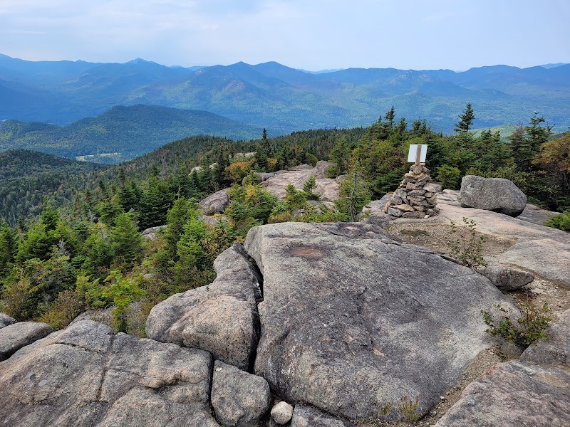
Midway up, the forest opens, revealing exposed rock faces and wild blueberry bushes in the summer. The final stretch to the summit is steeper, but the effort is worth it. At the top, you’re greeted by a sprawling vista that includes Lake Champlain, the Green Mountains of Vermont, and the High Peaks of the Adirondacks. The iconic fire tower, a relic from the mountain’s days as a lookout, adds a touch of history and offers an even higher vantage point for those willing to climb its sturdy steps.

Hurricane Mountain’s summit is a place to linger. Pack a picnic, soak in the view, and let the mountain winds carry away the cares of everyday life. Whether you’re tackling this hike for the challenge, the scenery, or the simple joy of being in nature, Hurricane Mountain delivers on all fronts.


Adventure Guide: Hurricane Mountain Trail

Trail Details

  • Northern Trail: 6.8 miles round trip, ~2,000 feet of elevation gain.
  • Alternate Trails:
    • Southern Trail: Shorter but steeper, 5.2 miles round trip.
    • Western Trail: A less-traveled route, 6 miles round trip.
  • Difficulty: Moderate, with some steep and rocky sections.

What to Bring

  • Essentials: Sturdy hiking boots, trekking poles, and a trail map.
  • Snacks and Water: High-energy snacks and at least 2 liters of water per person.
  • Extras: A camera for summit photos and binoculars for spotting distant peaks.

Best Times to Hike

  • Summer: Clear trails and vibrant greenery make for an enjoyable hike.
  • Autumn: Peak foliage transforms the landscape into a kaleidoscope of color.
  • Winter Adventures: Snowshoes and microspikes are essential for snowy conditions.

Driving Directions

From Lake Placid, take Route 73 toward Keene. Turn onto Hurricane Road and follow signs to the Northern Trailhead. Parking is available, but it can fill quickly on weekends.

Insider Tips

  • Start Early: Beat the crowds and enjoy cooler morning temperatures.
  • Weather Awareness: The summit is exposed; check forecasts and dress in layers.
  • Fire Tower Bonus: Don’t miss climbing the fire tower for an unforgettable perspective.

Hiking Hurricane Mountain is more than just a trail—it’s a journey through the beauty and history of the Adirondacks. Whether you’re a seasoned hiker or venturing into the mountains for the first time, this summit promises memories you’ll cherish long after you’ve descended.

Reviews

Tatsiana Mir2 months ago
Completed on 09/22/24. Great trail, moderate difficulty. When I saw the firetower from the road while headed to the parking I was really surprised how far and how high it looks and is it even possible to do it? Lol 😀 Well, in fact it took 2hr to get to the top (with very short breaks for the photos; I am in good shape and sometimes I walked fast, so for some people depending on other circumstances, I believe it can take longer, just consider the trail length). There is a nice overlook just in 15 mins as you start (next time if I have an extra hr, I would just go to that point 😀 ) And then a couple of more before you reach the firetower and the summit. It was pretty windy and chill on the top ( definitely take a jacket), but really amazing views. Firetower is open for climbing and for observing even better views. To get down to the parking it took close to 2hr, but I wasn't in hurry and made stops for more pictures The trail crosses a couple of small brooks and a pond...where it took me a moment to think if it's really safe to walk on those woods over that pond (as I had concern about how deep that pond could be - see on the pictures). The trail wasn't crowded, not much people on Sunday. Part of them were going down already at the time I started (at 12:30pm). So the trail goes to one of my favorite when you want a longer walk with less difficulties.
Charis Edwards2 years ago
Lovely trail up to the top of Hurricane Mountain. We camped in the woods 150 ft off trail - check out a topographic map before you come as you may not have service on the trail and it is very steep in many sections! The fire tower at the top is beautifully restored. There are 4 or 5 parking spots on the trailhead side of the road and the parking area is marked with a sign beforehand. The hike up to the top took about 2 hours and was very rewarding. The nearby towns look very cute, too and would be good spots to stop to stock up or use a bathroom before you hike! There are also shorter routes to the top on the other side of the mountain but i have not tried those out myself.
Patrick St-Denis3 months ago
Awesome 360° views from the summit and firetower.
Kevin Pearce3 months ago
The Hurricane Mountain Trail was a great adventure. The trail leads to a bald summit with a spectacular view of the surrounding mountains, which is amplified with a fire tower to get up even higher. The fire tower also has diagrams on it to help identify the sourrounding peaks. The trail itself is a straight forward hike on natural Earth along almost its entire length. There are a few short sections of boardwalks near the trailhead over muddh/ swampy areas. Near the top there are two places you need to climb up some large rocks to get onto the summit. There are ample foot and handholds, but this could be tricky if trying to carry a child in a carry backpack. There are multiple points along the trail that are good to stop at and enjoy the view. Near the point where you climb the rocks to the top was a sign towards an outhouse, and an adjoining trail. The trail is marked along the route on trees, then with paint along the rocks near the top, along with 2 official cairns. Some sections of the trail have a lot of loose mid sized rocks that seem worse on the way down. Careful with your footing to avoid turning an ankle. Parking at the trail head is a mix of a small parking lot and an extended section of large shoulder along the road. The trail head also has an outhouse. Great outing.
Catherine Abida5 years ago
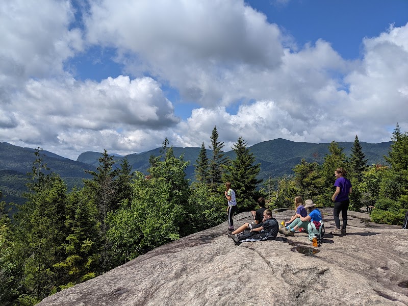
This hike has some of the best views in the Adirondacks in my opinion. The top of the mountain is open and has a lot of space so even on a busy day, you can have plenty of room to sit down and take in the views. This mountain is about 300" shy of being a high peak, but the views are better than on many high peaks.

Related Posts

featured

Hiking the Cascade Mountain Trail: A High Peaks Classic

featured

Mount Jo Loop Trail: A Perfect Adirondack Escape

featured

Saranac Lake 6er Challenge in Lake Placid

featured

Hiking the McKenzie Mountain Trail: A Challenging Adventure with Epic Views