Majestic Mt Nyiragongo: Nature's Fiery Spectacle
Adventure Destination

Majestic Mt Nyiragongo: Nature's Fiery Spectacle

Hike to the summit of Mt Nyiragongo, near Goma. This hard, 6-hour trek offers views of one of the world's largest lava lakes at Virunga National Park. Best visited in the dry season from June to September.

Hiking9.2/10Hard
Photo Gallery

Category

Hiking

Typical Duration

2-4 hours

Difficulty

Hard

About This Adventure Destination

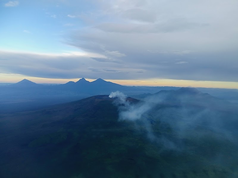
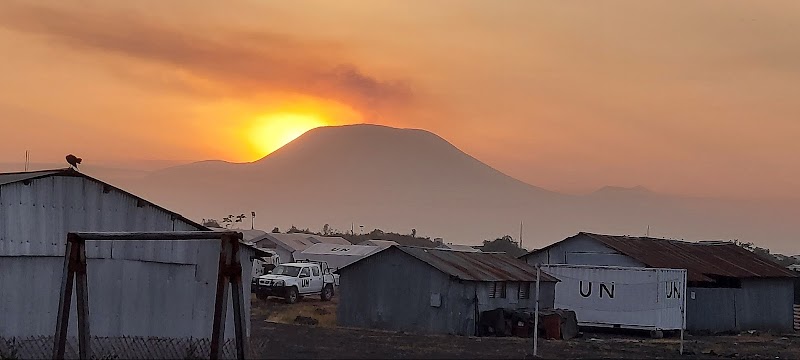
Mt Nyiragongo, located in the captivating Eastern region of the Democratic Republic of the Congo, near the bustling city of Goma, is a marvel of nature. This active stratovolcano is renowned for its mesmerizing lava lake, which is among the world’s largest and most dynamic. The vibrant orange and red hues from the bubbling lava create an awe-inspiring sight, especially when viewed against the backdrop of Lake Kivu's scenic expanse. Standing tall, Mt Nyiragongo not only offers geological wonders but also contributes to the rich biodiversity of the Virunga National Park. With its steep slopes and continuous volcanic activity, the mountain has captured the imagination and curiosity of geologists and adventure seekers alike. Historically significant, Mt Nyiragongo has been the subject of local folklore, with communities in the region passing down stories of this powerful giant for generations. As the sun sets, painting the sky with shades of gold, the silhouette of the volcano becomes a striking icon of the region's raw beauty.

Editorial Assessment

Mt Nyiragongo is a top-rated natural landmark due to its rare active lava lake and breathtaking hiking experiences within the Virunga National Park.

Majestic Mt Nyiragongo: Nature's Fiery Spectacle

Adventure Guide to Majestic Mt Nyiragongo: Nature's Fiery Spectacle

1

Experience Majestic Mt Nyiragongo: Nature's Fiery Spectacle

  • Special Features:

    Hike to the summit of Mt Nyiragongo, near Goma. This hard, 6-hour trek offers views of one of the world's largest lava lakes at Virunga National Park. Best visited in the dry season from June to September.

  • Visitor Tips:

    Best time to visit is during June to September. Bring adequate water, appropriate outdoor gear, and camera.

  • Directions:

    F6HX+5QP, Buhumba, Democratic Republic of the Congo

2

Exploring Near Goma, Democratic Republic of the Congo

  • Local Insights:

    Offers direct access to top trails, protected natural reserves, and picturesque viewpoints across Goma, Democratic Republic of the Congo.

  • Visitor Tips:

    Check local regulations, trail conditions, and weather before heading out.

3

Photography and Wildlife

  • Special Highlights:

    Capture panoramic sunrise and sunset views across the surrounding mountain terrain.

  • Visitor Tips:

    Arrive in early morning or late afternoon for the softest lighting and quieter trails.

Reviews

S
samirkumar lakhtaria9 months ago

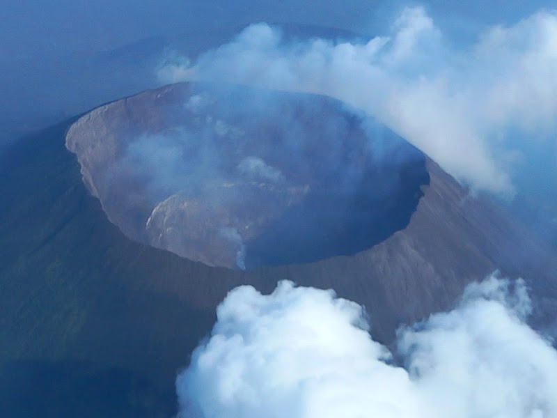
Mount Nyiragongo is an active stratovolcano with an elevation of 3,470 meters (11, 11, 5 in). Mountains associated with the Albertine Rift. It is located within Virunga National Park, in the Democratic Republic of Congo, about 12 km (7.5 mi) north of Goma and Lake Kivu north and west of the border with Rwanda. The main crater is about two kilometers (1 mi) wide and usually contains a lava lake. The crater currently contains two separate cooled lava benches within the crater walls – one at about 3,175 m (10,417 ft) and the lower one at about 2,975 m (9,760 ft). Nyaragongo's lava lake has sometimes been the best-known lava lake in recent history. The depth of the lava lake varies considerably. Prior to the January 1977 eruption, the maximum elevation of the lava lake was recorded to be about 3,250 m (10,660 ft) – a lake depth of about 600 m (2,000 ft). After the January 2002 eruption, a lava lake was recorded about 2,600 m (8,500 ft) or 900 m (3,000 ft) below the rim. Since then the level has gradually increased. Nyaragongo and nearby Nyamuragira are together responsible for 40% of Africa's historical volcanic eruptions. The volcano partially overlaps two older volcanoes, Baruta and Shaheru, and is also surrounded by hundreds of smaller volcanic cinder cones from flanking eruptions. Nyaragongo's cone consists of pyroclastics and lava flows. Nyaragongo lavas are low-silica, alkali-rich, ultramafic extrusive rocks that are essentially free of feldspars. They range from olivine-rich melilites to leucites to nephelinites, containing varying proportions of the minerals mainly nepheline, leucite, melilite, calcilite and clinopyroxene. Due to this very low silica composition, explosions occur with fluid flow in an unusual manner. While most lava flows move slowly and rarely pose a threat to human life, Nyaragongo's lava flow can run downhill at speeds of up to 100 km/h (60 mph). Not much is known about how long the volcano has been erupting, but it has erupted at least 34 times since 1882, including several periods where activity once continued for years, often in the form of churning lava lakes in the crater. The existence of a lava lake was suspected for some time but was not scientifically confirmed until 1948. Subsequent expeditions showed that the lake fluctuated in size, depth and temperature over time. Lava lake activity continues. As of 2020, the lake is largely confined to a broad, sloping cinder cone (about 18 meters (60 ft) high and 180 meters (600 ft) wide) at the crater floor. 1977 Between 1894 and 1977 the crater contained an active lava lake. On 10 January 1977, the walls of the crater cracked, and the lava lake erupted in less than an hour. Lava flowed up the side of the volcano at speeds of 60 km/h (37 mph) on the upper slopes, the fastest ever lava flow, inundating villages and killing at least 50 people. The villages of Kibati and Moniki, according to reports made at the time. Within 30 minutes, the lava lake was empty, flowing north, south and west of the volcano. Nowhere else in the world do such a steep-sided stratovolcano have such a liquid lava lake. [citation needed] Nyaragongo's proximity to heavily populated areas increases its potential to cause natural disasters. The 1977 eruption raised awareness of the unique dangers posed by Nyaragongo and led to its designation in 1991 as a volcano of the decade, worthy of special study. The 1977 eruption was triggered by the formation of a new small volcanic vent, Murara, a short distance up the slopes of Nyamuragira. 2002 explosion Make a change Eruptions in 1982–1983 and 1994 enhanced lava lakes in the crater. The volcano's second major eruption began on 17 January 2002, increasing seismic and fumarolic activity over several months. 13 kilometers (8.1 mi) of fissures opened on the south side of the volcano, spreading from 2,800 to 1,550 meters (9,190 to 5,090 ft) in a matter of hours.
M
Matheo12 months ago

Great destination! Enjoyed the open trail and peaceful outdoor atmosphere.

P
pritam sinha3 years ago

Live volcano.best for tracking and adventure

M
Michael Alain3 years ago

Most dangerous volcano in the city of Goma

J
John Primpas7 years ago

Great destination! Enjoyed the open trail and peaceful outdoor atmosphere.

Nearby Adventures

Bookable Experiences

Ten Days Among Mountain Gorillas, Chimps and the Kazinga Channel262.9 mi
Kampala, Central Region

Ten Days Among Mountain Gorillas, Chimps and the Kazinga Channel

A 10-day Kent Safari Tours itinerary that combines gorilla trekking in Bwindi, chimpanzee tracking in Kibale and game drives plus a Kazinga Channel launch on Queen Elizabeth — this guide lays out the daily flow, permit realities and practical planning.

262.9 miView Trips & Details →
Across Rift Valleys and Volcanoes: An 11‑day private sweep from Kampala to Rwanda’s gorilla forests262.9 mi
Kampala, Central Region

Across Rift Valleys and Volcanoes: An 11‑day private sweep from Kampala to Rwanda’s gorilla forests

An 11‑day, private safari route that links Kampala’s cultural pulse with rhino tracking, chimp and gorilla treks, big‑game drives and lake‑and‑river cruises—this guide lays out the daily flow, logistics and what to expect.

262.9 miView Trips & Details →
Six days between Uganda’s wildest extremes: Kidepo’s remote savanna to the thunder of Murchison Falls262.9 mi
Kampala, Central Region

Six days between Uganda’s wildest extremes: Kidepo’s remote savanna to the thunder of Murchison Falls

A 6-day Kent Safari Tours itinerary from Kampala linking Kidepo Valley and Murchison Falls national parks — wildlife drives, Ziwa rhino tracking, a Nile boat cruise and a hike to the falls.

262.9 miView Trips & Details →
Fifteen Days Across the Pearl of Africa: Gorillas, Game Drives and Village Life from Kampala262.9 mi
Kampala, Central Region

Fifteen Days Across the Pearl of Africa: Gorillas, Game Drives and Village Life from Kampala

A 15-day Kent Safari Tours itinerary that links Kampala to Uganda’s signature parks—Murchison Falls, Kibale, Queen Elizabeth, Bwindi and Lake Mburo—combining gorilla and chimp trekking, boat safaris and cultural village stays to help you plan a full-country circuit with logistics, permits and packing nailed down.

262.9 miView Trips & Details →
Savanna Songs and the Thundering Nile: Six Days Between Kidepo’s Wilds and Murchison Falls262.9 mi
Kampala, Central Region

Savanna Songs and the Thundering Nile: Six Days Between Kidepo’s Wilds and Murchison Falls

A six-day safari from Kampala that links remote Kidepo Valley and the Nile-carved drama of Murchison Falls — a practical guide to the itinerary, inclusions, and essential planning notes.

262.9 miView Trips & Details →
Four Days Inside Bwindi: A Private Gorilla Trek Through Moss, Mist and Local Life262.9 mi
Kampala, Central Region

Four Days Inside Bwindi: A Private Gorilla Trek Through Moss, Mist and Local Life

A four-day private safari from Entebbe/Kampala to Bwindi Impenetrable National Park focusing on gorilla trekking, bird watching and community visits; this guide explains the itinerary, gear and health considerations to prepare for the trip.

262.9 miView Trips & Details →