Exploring the Peaks of Maladeta
Adventure Destination

Exploring the Peaks of Maladeta

Explore the magnificent peaks of Maladeta in Huesca, Spain, including Aneto, the highest in the Pyrenees. This challenging area is perfect for hiking and wildlife watching. Best visited from late spring to early autumn, it's a must for adventure seekers.

Hiking9.1/10Hard
Photo Gallery

Category

Hiking

Typical Duration

2-4 hours

Difficulty

Hard

About This Adventure Destination

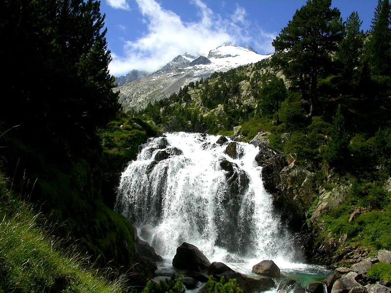
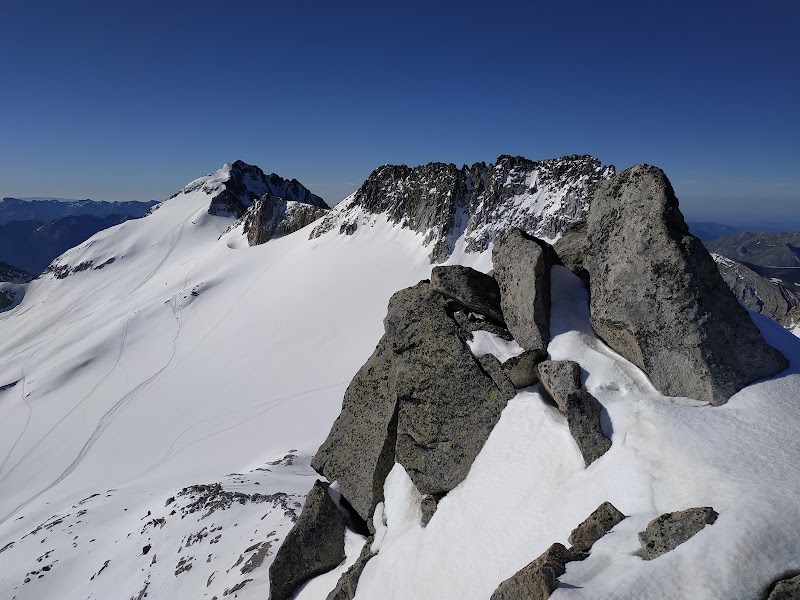
Maladeta, located in the beautiful region of Huesca, Spain, within the Pyrenees mountain range, is a must-visit for any nature enthusiast. This remarkable area is famous for its stunning peaks, with the iconic Aneto, the highest peak in the Pyrenees, as a breathtaking highlight. The snow-capped peaks provide a mesmerizing backdrop for those seeking a genuine alpine experience.

Maladeta's landscape is not only known for its towering mountains but also for its rich biodiversity. The glacial valleys surrounding the area harbor unique flora and fauna, with species that thrill botanists and nature lovers alike. The varied terrains represent a geological wonder, formed over millions of years, attracting scientists and outdoor adventurers who seek to understand and conquer.

Visitors will not only appreciate the natural beauty but can also engage in learning about the area's past. Rich in history and legend, the mountain range was called home by ancient populations whose stories add a mystical touch to the environment.

For those yearning for discovery, the Maladeta area offers wonderful opportunities for exploration. The juxtaposition of cultural heritage with raw natural beauty makes it an unforgettable destination.

Editorial Assessment

Maladeta's high rating stems from its unique combination of stunning alpine beauty, rich biodiversity, and historical significance, making it an extraordinary destination for adventurers and nature lovers alike.
Exploring the Peaks of Maladeta

Adventure Guide to Exploring the Peaks of Maladeta

1

Experience Exploring the Peaks of Maladeta

  • Special Features: Explore the magnificent peaks of Maladeta in Huesca, Spain, including Aneto, the highest in the Pyrenees. This challenging area is perfect for hiking and wildlife watching. Best visited from late spring to early autumn, it's a must for adventure seekers.
  • Visitor Tips: Best time to visit is during Late Spring to Early Autumn. Bring adequate water, appropriate outdoor gear, and camera.
  • Directions: Maladeta, 22440, Huesca, Spain
2

Exploring Near Huesca, Spain

  • Local Insights: Offers direct access to top trails, protected natural reserves, and picturesque viewpoints across Huesca, Spain.
  • Visitor Tips: Check local regulations, trail conditions, and weather before heading out.
3

Photography and Wildlife

  • Special Highlights: Watch for native wildlife including Pyrenean Chamois.
  • Visitor Tips: Arrive in early morning or late afternoon for the softest lighting and quieter trails.

Reviews

D
DARWIN3 months ago

The ascent to the summit of Maladeta (3,308 m) requires two days: the first to reach the Renclusa refuge (2,140 m) and the second for the summit push. My experience is as follows: On February 3, 2023, we set off from the parking lot before the Hotel Hospital de Benasque, right where the bus stop is located for access to the natural park in summer. The winter route begins there, as the snow makes access impossible and the track becomes a ski touring area, requiring us to walk along its right side. The warm-up walk takes you to the Besurta area (1,900 m) over 4 km with 160 m of elevation gain. Depending on your pace and how much you take photos, it can take around 1 hour 30 minutes to 2 hours. From there, you have a short but steep climb to the Renclusa refuge (2,140 meters), about 40 minutes of steady ascent, but with scenery that makes the journey much more bearable. In total, there's a 240-meter elevation gain to the refuge. Since it was winter and so cold, there were only eight of us staying. We all ate dinner at one table, and breakfast was provided for you to take to your room the next morning, as there was no breakfast service. The thermos of coffee stayed hot all night, which was surprising. The next morning, you have to get up quite early; you have to be walking by about 6:00 a.m. because it's a long and quite demanding day. You follow, in total darkness broken only by the light of your headlamp, the zigzags of the ski mountaineers who had been in the area in previous days. We set off from the refuge with snowshoes on; in fact, it was half-covered in snow. In about 5 hours we reached the base of the bergschrund. There, we had to leave our snowshoes stuck in the snow and put on our crampons, helmet, and ice axe (if we weren't already carrying them) and start climbing. The bergschrund is about 100 meters high, quite vertical at a 50° incline. The snow was hard, and only a rocky outcrop was visible. The steps were marked to show where to place the crampons. It was quite windy, and the gaps kept getting filled, so we had to keep making them. There was hardly time to think about anything other than planting the ice axe, putting on the crampons, and climbing. The only thought was getting down safely. Once we left the couloir, the wind was brutal. We put on our ski goggles, and from the false summit to the true summit, it was a few meters that we covered fairly quickly. The views from there were worth it, as always when you climb a peak of that magnitude. The snow-covered Pyrenees and the number of iconic mountains you can see were breathtaking. Time to descend. For me, the real celebration was at the base of the couloir on the way back. In the end, it wasn't so bad; the wind didn't make it easy, but little by little and safely, you descend to the start of the bergschrund. Once there, you swap crampons for snowshoes and head back to the refuge. You stop for a bite to eat along the way, since it wasn't possible at the summit, and enjoy the route. You stop at the refuge to collect your things from the locker, load your backpack, and head towards La Besurta. From there, you go to the parking lot and rest. My Garmin showed 15.6 km, 1,271 meters of elevation gain, and 13 hours (I didn't stop from the moment I woke up; we rested at the refuge, ate, packed our backpacks...), but those 10 hours were surely a constant effort. Without a doubt, a very rewarding experience in winter conditions, pure mountaineering in the heart of the Pyrenees. As a historical note, at the beginning of the 19th century (if I remember correctly), Maladeta was considered the main and highest peak in the entire Pyrenees, with Aneto in second place. In fact, the National Park is still called Posets-Maladeta. Enjoy the mountains!

E
Edgar Awad3 months ago

An incredible Solo climbing adventure to Pico Maladeta via Canal de la Rimaya without ropes in a critical time of year subject to hidden crevasses in maladeta glacier, icy path and little snow on the canal that makes the 50° vertical climb Epic that stays in memory forever❤ This adventure involves other peaks too. The video version of this adventure is now on my YouTube channel(Edgar Awad).

J
José luis Rodríguez montealegre5 months ago

Great destination! Enjoyed the open trail and peaceful outdoor atmosphere.

E
Elena Seco9 months ago

Great destination! Enjoyed the open trail and peaceful outdoor atmosphere.

F
Fina codina casalsa year ago

Great destination! Enjoyed the open trail and peaceful outdoor atmosphere.