Richat Structure
Adventure Destination

Richat Structure

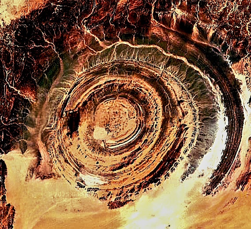
Explore the Richat Structure in Mauritania, often called the 'Eye of the Sahara.' This iconic geological wonder features concentric circles visible from space. Best visited from October to March, it attracts adventure seekers and photographers alike.

Geological Exploration8.8/10Moderate
Photo Gallery

Category

Geological Exploration

Typical Duration

2-4 hours

Difficulty

Moderate

About This Adventure Destination

The Richat Structure, commonly known as the “Eye of the Sahara,” is a vast and striking circular formation located near the historic town of Ouadane in Mauritania’s arid Sahara region. Spanning roughly 40 kilometers in diameter, this fascinating feature stands out against the desert’s monotone landscape and is visible from space, making it a rare geological spectacle. Its concentric rings of eroded rock layers draw both scientists and travelers eager to witness a natural wonder unlike any other in the area.

The Richat Structure’s unique shape results from circular erosion patterns exposing sedimentary, igneous, and hydrothermally altered rocks. In the center, ancient siliceous breccias appear, surrounded by high-relief quartzite ridges that form the characteristic “bullseye.” This formation is an eroded geological dome, not a meteorite crater, and it reveals layers dating back from the Late Proterozoic to the Ordovician period. Besides its geological allure, the site is rich in Paleolithic artifacts, providing a tangible connection to ancient human inhabitants and cultures.

Visitors will find the remote desert landscape both peaceful and challenging, with intense heat common during the day, especially in early autumn months. Vendors near the outer rings offer interesting relics found on-site, adding a local flavor to the experience. The Richat Structure combines natural wonder, intriguing scientific mystery, and historical depth, making it a memorable destination for those willing to venture off the beaten path in the Sahara.


Editorial Assessment

**LaunchPad Value:** The Richat Structure is a unique geological formation, renowned for its distinct features visible from space. While isolated, its natural beauty and scientific intrigue create a captivating experience for adventurous travelers. Its score reflects its significance as a natural wonder, yet its remoteness can limit accessibility.#RichatStructure #GeologicalWonders #Mauritania #AdventureTravel #NaturalLandmarks

Richat Structure

Adventure Guide to Richat Structure

1

Unique Outdoor Adventures

  • Details:

    Desert Hiking Around the Rings Trek along the outer quartzite ridges for panoramic views of the concentric circles. The terrain is rugged, so sturdy footwear is essential. Early mornings or late afternoons offer cooler temperatures and softer lighting for photography.

  • Details:

    Drone Flying and Aerial Photography The Richat’s true scale is best appreciated from the air. Visitors with drones can capture breathtaking shots of the bullseye formation. The remote location ensures clear skies, perfect for aerial exploration, but bring extra batteries and check local drone regulations.

  • Details:

    Archaeological Site Visits Near Ouadane Venture to nearby Paleolithic sites where Acheulean stone tools have been discovered. Local guides provide historical insights and help visitors understand the ancient significance of the area, enriching the experience with regional culture and lore.

2

Local Insights and Visitor Tips

  • Best Time to Visit:

    October through March, when desert heat is less intense. Daytime temperatures are then more manageable, though layering is advisable due to chilly nights.

  • What to Bring:

    Ample water, sun protection (hat, sunscreen, sunglasses), supportive shoes for rocky terrain, and a camera or drone for capturing stunning views.

  • Getting There:

    From Nouakchott, the capital of Mauritania, expect a 10-hour drive (approximately 500 km) on desert roads toward Ouadane, then a shorter journey to the Richat. Hiring an experienced local guide or driver is recommended for safety and navigation.

  • Cultural Notes:

    Engaging with local vendors and guides around the site can provide unexpected stories and access to artifacts. Remember this is a remote, unmanaged location—plan accordingly and respect the environment. Whether fascinated by geology, history, or desert landscapes, visitors will find the Eye of the Sahara an unforgettable encounter with one of Africa’s most extraordinary natural phenomena.

Reviews

E
Ebouh Khatariin the last week

Great destination! Enjoyed the open trail and peaceful outdoor atmosphere.

R
RONNAN GAMINGin the last week

It is an eroded geological dome , 40 kilometers (25 miles) in diameter caused by subsurface igneous rock intrusion that damaged the overlying layers of sedimentary rock , causing the rock to be exposed as concentric rings with the oldest layers exposed in the center of the structure. Igneous rocks are exposed inside and there are rhyolites and gabbros that have undergone hydrothermal alteration, and megabreccia in the center . This structure is also the location of a remarkable accumulation of Acheulean Paleolithic stone tools. It was selected as one of 100 geological heritage sites identified by the International Union of Geological Sciences (IUGS) as having the highest scientific value source: wikipedia

D
Damián Rakin the last week

Great destination! Enjoyed the open trail and peaceful outdoor atmosphere.

A
Andres Salgadoa week ago

ATLANTIS HAS BEEN FOUND and was washed away in Noah’s Flood.

W
WAGNALORa week ago

Great destination! Enjoyed the open trail and peaceful outdoor atmosphere.

Nearby Adventures

Bookable Experiences

Paddle Surf at Anfi del Mar: Calm Seas, Full‑Body Flow493.8 mi
Mogan, Las Palmas

Paddle Surf at Anfi del Mar: Calm Seas, Full‑Body Flow

A guided paddle‑surf session in Mogan that blends gentle exercise, professional instruction, quality gear and on‑board photography for a relaxed day on Anfi del Mar.

493.8 miView Trips & Details →
Entre azules y silencio: la travesía desde Playa Blanca a la Isla de Lobos502.2 mi
Playa Blanca, Las Palmas

Entre azules y silencio: la travesía desde Playa Blanca a la Isla de Lobos

Un trayecto en ferry desde Playa Blanca a Fuerteventura (aprox. 30 minutos), seguido de un traslado en barco a la Isla de Lobos con tiempo libre y horarios flexibles.

502.2 miView Trips & Details →
Private 13m sailyacht: Chart your own course along Fuerteventura’s coast and follow playful dolphins513.1 mi
Solana Matorral, Canarias

Private 13m sailyacht: Chart your own course along Fuerteventura’s coast and follow playful dolphins

A 3.5-hour private charter for up to eight people where you choose the route, enjoy onboard snacks and drinks, and seek out dolphins off Solana Matorral.

513.1 miView Trips & Details →
Five Hours in Jandia’s Emerald: Private Flounder Motor Boat for Up to Five513.1 mi
Solana Matorral, Canarias

Five Hours in Jandia’s Emerald: Private Flounder Motor Boat for Up to Five

A private 5-hour motor-boat rental from Solana Matorral that lets small groups explore Jandia’s green waters, anchor on secluded beaches and search for dolphins at their own pace.

513.1 miView Trips & Details →
Jet-ski Freedom off Morro Jable: Speed, Balance and Calm Coastal Runs513.2 mi
Morro Jable, Canarias

Jet-ski Freedom off Morro Jable: Speed, Balance and Calm Coastal Runs

Guided Moto-Jet Ski sessions from 20 to 50 minutes that pair high-adrenaline driving with relaxed coastal excursions — a practical guide to what to expect.

513.2 miView Trips & Details →
Sunset Sail from Morro Jable: A Private 3–4 Hour Cruise Along Fuerteventura’s Southern Coast513.4 mi
Morro Jable, Canarias

Sunset Sail from Morro Jable: A Private 3–4 Hour Cruise Along Fuerteventura’s Southern Coast

A private 3- or 4-hour evening cruise departing Puerto del Morro Jable where guests sip cava, listen to music and may spot wild dolphins as the sky turns gold.

513.4 miView Trips & Details →