The Channels Natural Area Preserve
Adventure Destination

The Channels Natural Area Preserve

Explore the sandstone corridors of The Channels near Saltville, VA. Discover unique rock formations in this preserve, perfect for hiking and birding. Best visited in spring and fall for mild weather and colorful views.

Hiking8.2/10Moderate
Photo Gallery

Category

Hiking

Typical Duration

2-4 hours

Difficulty

Moderate

About This Adventure Destination

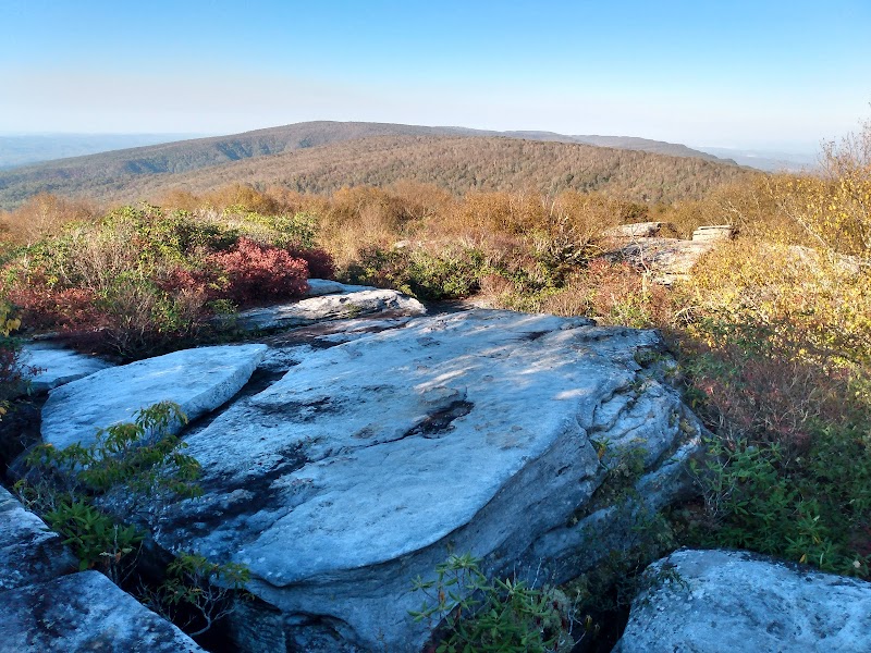
The Channels Natural Area Preserve, located near Saltville in southwestern Virginia, is a captivating destination where nature's artistry is on full display. Perched atop Clinch Mountain, this preserve features an extraordinary network of narrow sandstone corridors carved by natural erosion over countless millennia. Stretching over 400 acres, it stands apart in the region for its exceptional geological formations that create a maze-like series of passages. The distinctive channels are framed by rugged rock walls and winding paths, offering visitors a unique and engaging landscape to navigate. This area is also home to vibrant plant communities, including flourishing patches of mountain laurel and huckleberry, which add color and texture to the rocky environment.

Visitors often remark on the rich history tied to the site, as the land holds cultural significance for Native American groups who once used it. The Channels provide more than just visual intrigue—they invite curiosity about the slow geological processes that sculpted these features. The hike up Clinch Mountain leads past an old fire tower before reaching the striking stone corridors, rewarding those who make the climb with immersive views and photo-worthy moments. The rugged terrain and intricate rock formations make it a one-of-a-kind spot for outdoor enthusiasts looking for a blend of natural beauty and geological wonder in Virginia’s mountainous heartland.


Editorial Assessment

**LaunchPad Value**: The Channels Natural Area Preserve scores an **82** due to its unique geological formations and rich history. While a remarkable destination for nature lovers, its less prominent status compared to global landmarks affects its ranking slightly. An ideal location for those seeking adventure off the beaten path.#hiking #nature #Virginia #geologicalwonders #ClinchMountain #TheChannels #outdooradventure
The Channels Natural Area Preserve

Adventure Guide to The Channels Natural Area Preserve

1

Hiking The Channels

  • What makes it special:

    The main trail is about 3.5 miles one-way, leading uphill to the sandstone channels where natural corridors twist and turn.

  • Key features:

    Well-maintained paths with about 1,600 feet of elevation gain, old fire tower views on the way, and a fascinating rock maze at the summit.

  • Local insights:

    The Channels are not slot canyons but formed by natural sandstone erosion over millions of years. Early arrival is essential due to limited parking (only 10 spots). The site holds Native American historical ties and offers tranquil mountain vistas.

  • Visitor tips:

    Go in spring or autumn for mild weather. Bring plenty of water, sturdy hiking shoes, and a camera. Arrive early on weekdays to secure parking and avoid crowds.

2

Rock Climbing & Scrambling

  • What makes it special:

    Kids and adults alike enjoy climbing the large sandstone blocks and navigating natural rock steps inside the channels.

  • Key features:

    Safe, low-impact scrambling spots with plenty of nooks and ledges to challenge your agility.

  • Local insights:

    The channels encourage hands-on interaction with nature’s formations, making it ideal for families and adventure seekers.

3

Wildlife & Botanical Viewing

  • What makes it special:

    The preserve hosts mountain laurel blooms and native berries, with occasional bird watching opportunities.

  • Key features:

    Diverse plant life adapted to rocky terrain enhances seasonal colors and supports local fauna.

  • Local insights:

    Spring brings vibrant flowers; fall offers colorful foliage backdrop against sandstone walls.

4

Getting There & Practical Advice

  • Directions:

    From Saltville, take VA-80 south for about 10 miles toward Hayters Gap; the parking area sits right at the roadside.

  • Travel time:

    About 20 minutes from Saltville town center.

  • Important:

    No roadside parking allowed—violators risk towing. Carpooling recommended for groups.

  • Packing list:

    Water (1-2 liters), snacks, sturdy shoes, sun protection, and allergy meds if needed. This site offers an unforgettable journey through ancient stone corridors that feel both adventurous and serene, making it a must-visit for nature lovers in Southwest Virginia.

Reviews

A
Anna Vaterin the last week

Great destination! Enjoyed the open trail and peaceful outdoor atmosphere.

D
Dusty Norris3 months ago

This is an amazing hike, well worth it. For experienced hikers, it takes a bit over an hour to reach the summit, but of course, there is a great reward at the top. I'd highly recommend.

A
Anthony3 months ago

WOW!!! What an incredible place to visit! My kids love to climb around rocks and explore and this offered so much of it. The landscape and way the rocks have formed these paths and maze is just awesome! I am definitely recommending this to all who like the outdoors and hiking. The only complaint I have about this trip was the limited amount of parking. There are only 10 spots available to park in. This can be a pro though in a way because it keeps out from being overly crowded like some hiking trails can be.

M
Micah Baxter4 months ago

Would love to have walked up and seen the area. But parking was so full we couldn't go. Parking max is 10 cars and there was 15 parked in the parking lot and I was in a 1500 truck, so couldn't squeeze in. I should have gotten there at 6am like the rest of the crowd.

T
Teresa Williford2 months ago

This is an amazing hike! Most of it is gravel but the last mile gets so much better and is so worth it. Go early, limited parking.

Nearby Adventures

Bookable Experiences

Skip the Queue at Splash!: How Advance Admission Locks in a Day at Breaks’ Waterpark14.0 mi
Breaks, Virginia

Skip the Queue at Splash!: How Advance Admission Locks in a Day at Breaks’ Waterpark

Advance Admission to Splash! in the Park guarantees your entry on the reserved day, provides access through a separate entrance for quicker lines, and must be purchased by 11:59pm the night before your visit.

14.0 miView Trips & Details →
River Challenge: Wade, Climb and Crawl Through Bristol Caverns’ Underground Creek22.3 mi
Bristol, Tennessee

River Challenge: Wade, Climb and Crawl Through Bristol Caverns’ Underground Creek

A 3-hour guided expedition that follows an underground creek through slick limestone corridors, chest-deep pools and rugged stone ledges — this guide explains what to expect and how to prepare.

22.3 miView Trips & Details →
Wading the Cavern Creek: A Moderately Challenging Underground Riverwalk in Bristol23.0 mi
Bristol, Tennessee

Wading the Cavern Creek: A Moderately Challenging Underground Riverwalk in Bristol

A guided route through a shallow, winding subterranean stream that mixes easy passageways with moments of exploration—this guide explains what to expect and how to prepare.

23.0 miView Trips & Details →
Paddling the Tug Fork: Kayak Rentals from CoalTown’s Campground in Welch25.3 mi
Welch, West Virginia

Paddling the Tug Fork: Kayak Rentals from CoalTown’s Campground in Welch

Half- and full-day kayak rentals launched from CoalTown Camping and Recreation Center give paddlers of all levels direct access to the Tug Fork River; this guide distills what to expect and how to plan.

25.3 miView Trips & Details →
Riverfront Quiet: Arcadia Campground’s New Campsite #4 on the James River28.1 mi
Buchanan, Virginia

Riverfront Quiet: Arcadia Campground’s New Campsite #4 on the James River

A riverside tent-only site in Buchanan, VA — camp at one of ten drive- or paddle-access riverfront sites with picnic tables and fire rings; guide summarizes access, amenities, and planning essentials.

28.1 miView Trips & Details →
Ridge Runs and Deep-Woods Overlooks: A Four-Seat Kawasaki Teryx on Haysi’s Ridgeview Trail30.3 mi
Haysi, Virginia

Ridge Runs and Deep-Woods Overlooks: A Four-Seat Kawasaki Teryx on Haysi’s Ridgeview Trail

Drive a four-seat Kawasaki Teryx on Haysi’s Ridgeview Trail — 54 miles across 2,650 acres — with 4- or 8-hour rentals and helmets included.

30.3 miView Trips & Details →