Hiking to the Iceline Trail for Stunning Glacial Views in Yoho National Park, BC
Hiking to the Iceline Trail for Stunning Glacial Views in Yoho National Park, BC
Introductory Overview
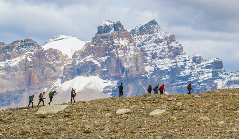
The Iceline Trail in Yoho National Park, BC offers some of the most breathtaking alpine scenery in the Canadian Rockies. Known for its dramatic glacier views, high-altitude trekking, and diverse landscapes, this trail is a must-do for avid hikers looking for a challenging but rewarding experience. The route provides panoramic vistas of the President Range, Takakkaw Falls, and Yoho Glacier, making it one of the park’s premier hikes. The combination of rocky moraines, lush forested sections, and pristine alpine lakes ensures a dynamic hiking experience.
### Adventure Guide To Hiking to the Iceline Trail for Stunning Glacial Views
Route Details & Highlights
- Trailhead Location: Begin at the Takakkaw Falls parking lot, approximately 1 hour from Lake Louise.
- Distance & Elevation: A 13-20 km loop, depending on the chosen route, with gain of 700-900 meters.
- Key Attractions: Views of Yoho Glacier, Emerald Glacier, and Takakkaw Falls from high above the valley floor.
- Difficulty Level: Moderate to strenuous due to steep switchbacks and exposed sections.
Best Viewpoints & Notable Stops
- Iceline Summit: The highest point of the trail, offering a spectacular panorama of glacial formations and rugged peaks.
- Celeste Lake Connector: A serene alpine lake stop for those opting for the extended loop.
- Laughing Falls: A picturesque waterfall along the Yoho Valley floor, often part of the return route.
Wildlife & Ecosystem
- The trail traverses multiple ecosystems, from dense subalpine forests to barren moraines shaped by ancient glaciers.
- Possible wildlife sightings include mountain goats, marmots, and pikas—stay alert and respect wildlife.
Local Insights
- The Iceline Trail derives its name from its close proximity to retreating glaciers, forming a stark contrast between ice and exposed rock.
- Constructed in the mid-20th century, it was designed to offer views of glacial recession over time.
- The Takakkaw Falls area, where the hike begins, features one of the tallest waterfalls in Canada at 373 meters.
Visitor Tips
- Best Time to Visit: Late July to September for snow-free trails and optimal weather.
- What to Bring: Layers for rapidly changing temperatures, sturdy hiking boots, plenty of water, bear spray, and a camera.
- Driving Directions: From Banff, take the Trans-Canada Highway west for 90 km and follow Yoho Valley Road to Takakkaw Falls (closed in winter).
- Trail Safety: Expect rocky terrain and exposed sections—start early to avoid crowds.
Adventure Map
Reviews
Simona Voinica year ago
The most beautiful place in the world. 8 hour hike for the average hiker. Breathtaking views.
Rob Maciaka year ago
Terrific trail! Multiple options including out-and-back (14 kilometres), shortcut loop (17 kilometres), or full loop (20 kilometres). Phenomenal views of Yoho Valley, The President, The Vice President, Mount Stephen, etc. and you can even scramble up to several unnamed glaciers along the way. Lovely day for sure! Just be sure to be safe on the drive up, those road switchbacks are pretty sharp (especially one of them). Very well maintained trail with lots of fresh water lakes and bridges. Check out the photos! 💪🏽👊🏽💥🤟🙂
Harveer Singh Gurjara year ago
Hoke is moderate. You will have some lovely view points
R3CKL3SS H3R0a year ago
Very nice trail to walk if you have time and a basic to giod condition.
It took us 6,5 hours to complete the 20 km trail.
We had all kinds of weather, so make sure you have the proper shoes and equipment.
The trail it self was changing during our hike, from a nice path to small rocks and big rocks/boulders.
We walked the trail counter clock wise... luckily, because if we had to start where we ended I don't think we would have pushed through 😉.
Amir Feizollahia year ago
Mind blowing trail with gorgeous views. Totally recommend it. We took the trail to the Laughing Falls. It’s classed as easy to moderate hike. It gets a bit more challenging from there to the cabin if you are interested. Free parking!
Related Posts