TOBYHANNA AIR ACTIVITIES FIELD GUIDE
Above the Gap: A 30‑Minute Airborne View of the Delaware Water Gap
A compact 30-minute airplane tour from Pocono Mountains Airport that lifts you over forested valleys, hiking trails, and the river gorge for unforgettable aerial perspectives.
Above the Gap: A 30‑Minute Airborne View of the Delaware Water Gap.
Adventure brief
Above the Gap: A 30‑Minute Airborne View of the Delaware Water Gap
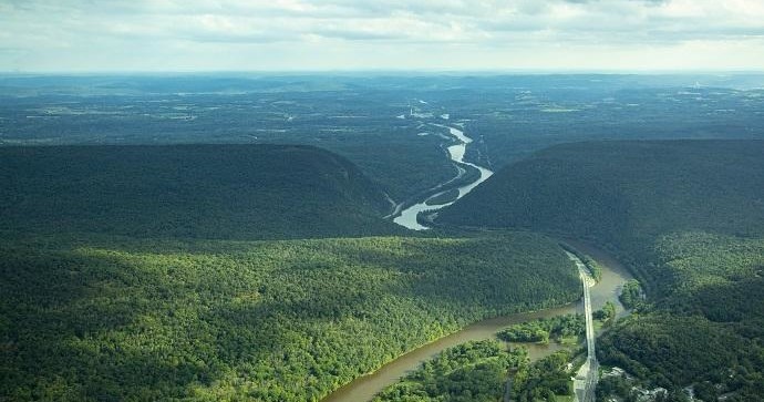
Take to the skies on a 30‑minute airplane tour that climbs out of the Pocono Mountains Airport and threads a path over the Delaware Water Gap. From above, the dramatic break in the ridge, ribboning river and surrounding forested valleys resolve into patterns that are otherwise only suggested from the trailhead—an accessible, concentrated way to see the landscape’s scale and shape.
Experience the thrill of soaring above the scenic Delaware Water Gap with the private Delaware Water Gap Air Tour offered by Hop On Air LLC. This exclusive air adventure provides breathtaking views of lush forests, winding rivers, and rugged mountain cliffs combined with the comfort of a private flight. Perfect for adventure seekers and nature lovers alike, this tour offers a unique perspective of Pennsylvania's natural beauty from the sky. Whether you're celebrating a special occasion or simply looking to elevate your outdoor experience, the air tour promises memorable sights and moments. The flight is tailored to ensure a comfortable, educational, and exhilarating experience, with knowledgeable pilots sharing insights about the area's history and geography. As you glide over the Delaware River and surrounding landscapes, you'll capture stunning photo opportunities and enjoy the serenity of aerial exploration. This adventure is perfect for those seeking a combination of excitement, scenic beauty, and exclusive access. Hop On Air LLC's professional team ensures your safety and comfort, making this a remarkable way to explore Pennsylvania from above and create lifelong memories of your outdoor adventure.
Route Schematic
Route & Schematic
The flight departs from Pocono Mountains Airport and follows a brief circuit that highlights the river gap, surrounding valleys and visible hiking routes.
Pocono Mountains Airport — Departure
Takeoff and climb from the airport set the stage for the aerial tour that follows the Delaware Water Gap corridor.
Delaware Water Gap — The Gorge
The flight brings the river gorge and the defining break in the ridgeline into view, offering clear perspectives on the Gap’s scale and form.
Forested Valleys & Trails — Overhead Views
Passes over surrounding forested valleys and visible hiking trails reveal the pattern of ridges, hollows and recreational corridors below.
Operator requires a minimum of 2 passengers and limits each flight to a maximum of 3 passengers; bookings for solo travelers may not meet minimums and could be rescheduled.
What the day feels like
What the Flight Feels Like
The experience is brisk and cinematic: a short roll at Pocono Mountains Airport, a steady climb, and then a series of low‑level passes that frame the Delaware Water Gap, the river carving through the ridge, and the contiguous forests and trails below. It’s an intimate airborne snapshot—designed to deliver the region’s best features in a single, memorable circuit.

THE LANDSCAPE
The Delaware Water Gap from a New Angle
Soar directly above the river gorge and the gap that carves through the ridgeline; the flight’s short duration concentrates the region’s dramatic geology into a single, sweeping view.

THE ROUTE
Rivers, Ridges and Forested Valleys
The route showcases the surrounding forested valleys and the network of hiking trails below, offering a distinctive vantage on the landscape’s lines and textures from above.

THE NOTEWORTHY
A Short, Photo‑Friendly Flight
At just 30 minutes, the tour is compact and accessible—designed for sightseeing and photography, making it an efficient way to capture aerial images and impressions.
Suitability
Who it's for
Who this short air tour suits — and who it does not.
Practical planner
Details to review before reserving
The tour offers aerial photo opportunities—bringing a camera or phone for photography is recommended.
The experience is a focused, 30‑minute airplane tour—compact and designed for sightseeing rather than prolonged airborne travel.
Review cancellation policies before reserving.
Frequently asked questions
Planning Your Outing
How long is the Delaware Water Gap Air Tour?
The tour lasts 30 minutes.
Where does the flight depart from?
Flights depart from Pocono Mountains Airport.
What aircraft is used for the tour?
The experience is an airplane tour.
How many people can fly together?
Each flight requires a minimum of two passengers and is limited to a maximum of three passengers.
Is the tour suitable for first‑time flyers and photographers?
Yes—this short, accessible tour is described as ideal for first‑time flyers and for sightseeing and photography.
What will we see on the flight?
The flight showcases aerial views of the Delaware Water Gap, surrounding forested valleys, and visible hiking trails.
How this guide was prepared
This field guide is synthesized using verified supplier specifications, route descriptions, and destination data. Some booking links may generate affiliate revenue for ADV Guides.
- Verified: 2026-09-18T12:03:15.746Z
Some booking links may generate revenue for ADV Guides or The Adventure Collective.
Availability, pricing, schedules and operating details can change.
Trip details and contextual sources were reviewed by ADV Guides Editorial.