VOSSEVANGEN HIKING FIELD GUIDE
A steep day up Mt. Oksen for 360-degree fjord panoramas
A full-day, off-the-beaten-track hike from Vossevangen to the 1,241 m summit of Mt. Oksen, useful for planning the route, logistics, and required gear.
A steep day up Mt. Oksen for 360-degree fjord panoramas.
Adventure brief
A steep day up Mt. Oksen for 360-degree fjord panoramas
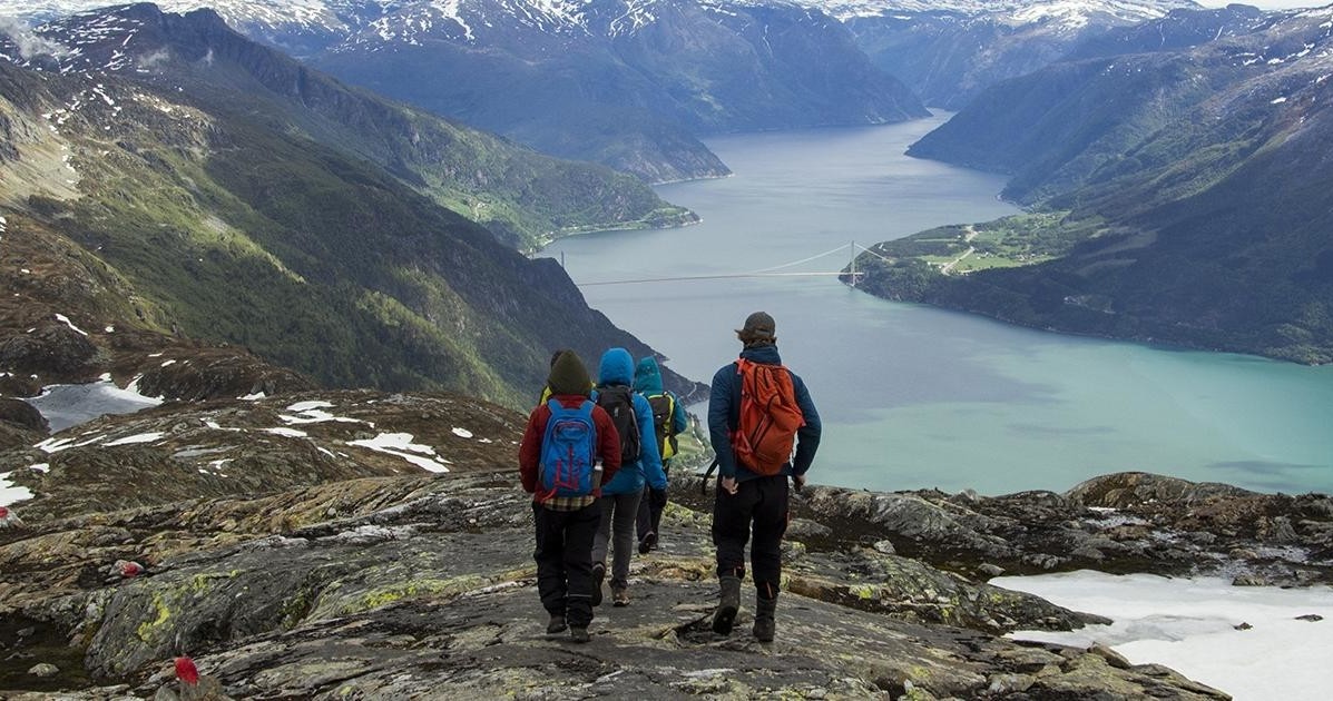
Set out from Voss on a full-day fjord hike that winds up from Tjoflot through native forest and a series of demanding climbs to the 1,241 m summit of Mt. Oksen. Above the treeline the terrain opens, and at the top you are rewarded with sweeping 360-degree views over Samlafjorden, Sørfjorden, Eidfjorden and Granvinsfjorden, with the mountain ridges around Voss and the Folgefonna glacier filling the horizon.
Vossevangen, in Norway’s Hordaland region, serves as an ideal starting point for outdoor enthusiasts seeking a challenging full-day hike. Outdoor Norway specializes in guiding visitors through rugged terrains and pristine landscapes, offering an immersive experience atop Mt. Oksen. This hike isn’t just about reaching the summit; it’s about experiencing Norway’s wild beauty firsthand. The trail meanders through dense, moss-covered forests, with towering birch and spruce trees that give way to rocky outcrops. As you ascend, the terrain becomes steeper and more demanding, rewarding climbers with spectacular panoramic views. Reaching the summit means standing amidst a sweeping 360-degree vista, with four formidable fjords stretching into the distance, carved through geological ages by glacial forces. The summit’s stark, rugged rock formations contrast sharply with the lush valleys below, offering a picture-perfect backdrop for photographs. Historically, this area has been a vital part of Norway’s rugged terrain, with local legends tying the mountain to centuries of outdoor life. The route is suited for hikers with a moderate to challenging level of fitness, and it provides an authentic taste of Norway’s untamed wilderness. Because of the variable terrain, it’s wise to prepare with proper gear and be mindful of changing weather conditions, especially in spring and fall. Outdoor Norway’s guided hikes provide insight into the region’s geological features and local flora and fauna, making it a truly enriching experience for adventure seekers. Whether summiting in summer’s long daylight or in winter when snow cloaks the landscape, this trek remains a highlight for outdoor lovers. With careful planning and the right gear, the journey up Mt. Oksen offers a meaningful challenge paired with unforgettable views of Norway’s wild heart.
Route Schematic
Route Schematic & Key Stops
Key moments along the itinerary, from check‑in to the summit and the return shuttle.
Outdoor Base — check‑in & gearing
Participants check in at the operator's Outdoor Base shortly before departure, get fitted with any shared gear and receive safety briefings.
Shuttle to trailhead (Tjoflot/Hardangerfjord)
A short shuttle transfers the group to the starting point near Hardangerfjord/Tjoflot from which the uphill trail begins.
Ascent through native forest and steep sections
The trail winds up through native forest and then climbs steadily above the treeline; the route includes particularly steep stretches between roughly 400–600 m and again near 800 m.
Summit — 1,241 m panoramic lookout
At the summit enjoy 360° views over four fjords and the surrounding mountain ridges, with sightlines toward the Folgefonna glacier.
Return descent and shuttle back to Voss
After a summit break the group descends the same route and is shuttled back to the Outdoor Base in Voss.
This is a demanding hike that requires a good level of fitness and appropriate clothing and sturdy footwear; the operator may modify timing or route for safety and conditions.
Highlights
Outing Highlights
A summit that looks out on four fjords
The climb tops out at 1,241 m and delivers uninterrupted, 360-degree views over Samlafjorden, Sørfjorden, Eidfjorden and Granvinsfjorden, plus wide panoramas toward the Folgefonna glacier and the surrounding mountain ridges.
Forest, steep climbs and an exposed high ridge
The trail begins in Tjoflot and climbs through native forest before a demanding ascent above the treeline; the route climbs roughly 990 m from the car park and includes particularly steep sections on the way up.
Chance encounters on an off‑the‑beaten‑track hike
On this less‑traveled fjord hike there is a possibility of spotting reindeer grazing along parts of the ascent.
What the day feels like
What the full day feels like
This is a sustained, full‑day outing: check in and gear up at the Outdoor Base, take a short shuttle to the trailhead, then push through an initially steep forested approach that gives way above the treeline to increasingly expansive views. The highest sections are exposed and rewarding; after a summit stop the group returns along the same route and is shuttled back to the base in Voss.
Suitability
Who it's for
Who this hike suits — and who should reconsider.
Practical planner
Details to review before reserving
This is a full‑day outing with a scheduled duration of about 7 hours; participants should allow for a full day for the shuttle, ascent, summit break and descent.
Check in at the operator's Outdoor Base about 10 minutes before the scheduled departure; the itinerary includes a shuttle to the trailhead and a shuttle back to the Outdoor Base in Voss.
Wear appropriate clothing and sturdy footwear suited to mountain terrain and variable weather; the operator notes that appropriate clothing and footwear must be worn.
Expect a straight climb of about 990 m from the car park, with two especially steep sections between ~400–600 m and near 800 m; there are no described dangerous passages but the hike is demanding.
Review cancellation policies before reserving.
Frequently asked questions
Planning Your Outing
How long is the hike?
The full‑day hike has an expected duration of about 7 hours.
Where do I meet the group?
Participants check in at the operator's Outdoor Base shortly before departure; the itinerary specifies checking in about 10 minutes before your scheduled time.
How difficult is the route?
The hike is demanding and requires a good level of fitness; the trail climbs roughly 990 m from the car park and has particularly steep parts between about 400–600 m and again near 800 m.
Are there any hazardous passages?
No dangerous passages are described, but there are two especially steep sections on the ascent and the route is otherwise demanding, so appropriate footwear and caution are advised.
What should I wear and bring?
Wear appropriate mountain clothing and sturdy footwear as required by the operator; bring layers suitable for changing conditions and items you need for a full day outdoors.
What can I expect from the summit views?
From the 1,241 m summit you get 360° views that include Samlafjorden, Sørfjorden, Eidfjorden and Granvinsfjorden, plus panoramic sightlines toward the Folgefonna glacier and surrounding ridges.
How this guide was prepared
This field guide is synthesized using verified supplier specifications, route descriptions, and destination data. Some booking links may generate affiliate revenue for ADV Guides.
- Verified: 2026-08-10T12:51:03.259Z
Some booking links may generate revenue for ADV Guides or The Adventure Collective.
Availability, pricing, schedules and operating details can change.
Trip details and contextual sources were reviewed by ADV Guides Editorial.