Devils Bottom Conservation Area wilderness guide
Conservation Area · MO

Devils Bottom Conservation Area

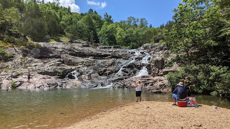
Devils Bottom Conservation Area in Missouri offers rugged terrain and scenic river views, making it an inviting destination for hiking, fishing, and wildlife observation.

Conservation Area1,1204+ Trails
DesignationConservation Area
Total Wilderness Area1,120
Elevation / TerrainDiverse Wilderness
Field Editorial Guide

About Devils Bottom Conservation Area

Devils Bottom Conservation Area in Missouri offers rugged terrain and scenic river views, making it an inviting destination for hiking, fishing, and wildlife observation.

Wilderness Landscape & Natural Heritage

Located in southeastern Missouri along the Current River, Devils Bottom Conservation Area spans rolling hills, forested ridges, and river bottomlands. The area features a mix of upland oak-hickory forests and bottomland hardwoods, providing habitat for diverse wildlife including white-tailed deer, wild turkey, and numerous songbirds. Historically, the land was used for small-scale farming and timber before being designated as a conservation area to protect its unique natural features and to promote outdoor recreation. Visitors can explore several miles of multi-use trails that wind through steep bluffs and scenic river frontage, ideal for day hikes or wildlife watching. The Current River itself is a popular spot for fishing, canoeing, and kayaking, offering a chance to experience clear waters bordered by rocky bluffs and dense forests. Devils Bottom also affords opportunities to observe rare plant species and a variety of migratory birds during spring and fall. Although facilities are modest to preserve the natural character, there are areas suitable for dispersed camping and picnicking. This conservation area appeals to outdoor enthusiasts seeking solitude, scenic beauty, and a chance to connect with Missouri’s river valley ecosystems.

Field Guide · Conservation Area
Adventure Destinations

Notable Destinations Near Devils Bottom Conservation Area

Scenic viewpoints, outdoor landmarks, and notable points of interest within 60 miles.

Key Wilderness Highlights

✦ Scenic bluff overlooks along the Current River✦ Upland oak-hickory forest with diverse wildlife✦ Quiet river access points for canoeing and fishing✦ Remote trails offering solitude and birdwatching opportunities
Wilderness Recreation

Outdoor Adventures in Devils Bottom Conservation Area

Explore curated guides for top outdoor sports, trail networks, and wilderness activities.

Park Recreation

Hiking

Available in Devils Bottom Conservation Area
Park Recreation

Fishing

Available in Devils Bottom Conservation Area
Park Recreation

Canoeing

Available in Devils Bottom Conservation Area
Park Recreation

Wildlife Viewing

Available in Devils Bottom Conservation Area
Park Recreation

Birdwatching

Available in Devils Bottom Conservation Area
Park Recreation

Picnicking

Available in Devils Bottom Conservation Area
Park Recreation

Photography

Available in Devils Bottom Conservation Area
The Ranger Station

Visitor Logistics & Essential Planning

Everything you need to know about entrance passes, seasons, visitor centers, road transit, and wildlife safety in Devils Bottom Conservation Area.

Passes & Fees

Entrance Requirements & Interagency Passes

Free public access, no permits required for day use; camping may require a permit

Wilderness Checklist

Carry paper topographic map & compass in remote zones.
Store all food and scented items in approved bear canisters.
Check wildfire / smoke advisories before backcountry departure.
Pack out everything you pack in (Leave No Trace).
Wilderness Stays

Camping & Overnight Stays in Devils Bottom Conservation Area

Frontcountry developed campgrounds, backcountry wilderness permit guidelines, and starry-night camping advice.

Devils Bottom Primitive Campground

Basic campsite located near Current River with limited facilities; ideal for back-to-nature experience.

Adventure Basecamps

Gateway Towns Near Devils Bottom Conservation Area

Stay, dine, and gear up in these mountain towns and scenic basecamps surrounding the park.

Bunker, Missouri
⌖ 11.30 miles
Gateway Basecamp

Bunker, Missouri

Bunker offers outdoor travelers peaceful access to the Ozark foothills with hiking, fishing, and paddling nearby. It’s a quiet basecamp for exploring Mark Twain National Forest’s natural beauty.

Spring through Fall
Explore Town
Eminence, Missouri
⌖ 12.42 miles
Gateway Basecamp

Eminence, Missouri

Eminence, MO, is a serene destination for canoeing and hiking in the Ozark National Scenic Riverways. With crystal waters, lush trails, and rich wildlife, it’s a gateway to true nature experiences in the Ozarks.

Spring and Fall
Explore Town
Ellington, Missouri
⌖ 14.29 miles
Gateway Basecamp

Ellington, Missouri

Ellington, Missouri, is a quiet gateway town to the scenic Ozarks offering hiking, paddling the Current River, fishing, and camping in nearby national forest and state parks. Ideal for travelers who enjoy nature and outdoor solitude.

Spring through Fall
Explore Town
Centerville, Missouri
⌖ 17.49 miles
Gateway Basecamp

Centerville, Missouri

Centerville, Missouri, is a peaceful rural town ideal for paddling calm rivers, hiking forest trails, and fishing quiet waters. Perfect for travelers seeking low-key outdoor adventures surrounded by nature.

Spring through Fall
Explore Town
Van Buren, Missouri
⌖ 23.25 miles
Gateway Basecamp

Van Buren, Missouri

Van Buren offers a charming escape in the Ozarks, where canoeing, hiking, and fishing await in the serene beauty of the Current River and surrounding forests.

Spring and Fall
Explore Town
Lesterville, Missouri
⌖ 23.65 miles
Gateway Basecamp

Lesterville, Missouri

Lesterville is a quiet Missouri town offering easy access to the Mark Twain National Forest and Black River. Ideal for hiking, paddling, fishing, and camping, it’s a peaceful basecamp for exploring southern Missouri’s forests and waterways.

Spring through Fall
Explore Town
Expert-Led Wilderness Expeditions

Guided Experiences in Devils Bottom Conservation Area

Explore scenic backcountry routes and epic wilderness adventures with certified local mountain guides, naturalists, and outfitters.

Eminence to Two Rivers
ADVEXPEDITION
Eminence, Missouri
Water ActivitiesADV Bookable

Eminence to Two Rivers

Discover the calm waters of the Black River with a guided canoe or kayak trip near Eminence, Missouri. Perfect for all skill levels, these adventures offer a scenic escape into nature’s quiet beauty.

Water Activities8 Mile Trip • 4-6 Hours • Canoes, Kayaks, RaftsCertified Outfitter
Bookable OnlineBook Trip
HWY 8
ADVEXPEDITION
Leasburg, Missouri
KayakADV Bookable

HWY 8

Paddle 10 miles of winding rivers with Ozark Outdoors’ HWY 8 canoe and kayak trip. Navigate caves, gravel bars, and lush forests on a family-friendly float through Missouri’s Huzzah and Meramec waterways.

KayakCanoes/Kayaks only • Takes 5-6 hrs • 8 miles on the Huzzah/2 miles on the Meramec • All AgesCertified Outfitter
Bookable OnlineBook Trip
Skinner's Landing
ADVEXPEDITION
Leasburg, Missouri
KayakADV Bookable

Skinner's Landing

Spend a full day drifting eight miles down the Upper Meramec, passing limestone bluffs, caves, and gravel bars. Rafts, canoes, and kayaks accommodate families and groups—book early and arrive prepared to float back to Ozark Outdoors' Main Beach.

KayakMay 1 - September 14 • 5–8 hours (Rafts approx. 8 hours; Canoes/Kayaks 5–7 hours)Certified Outfitter
Bookable OnlineBook Trip
RZR Two Seater
ADVEXPEDITION
Farmington, Missouri
ATV/UTVADV Bookable

RZR Two Seater

Looking for a heart-racing off-road experience? Discover Midwest Sports Center's RZR rentals and hit the trails in the Midwest! Perfect for thrill-seekers of all levels.

ATV/UTVFrom $265 · Ages 21+ to Rent · 4 or 7 HoursCertified Outfitter
Bookable OnlineBook Trip