Hiking to Dewey Point via Glacier Point Road
Adventure Destination

Hiking to Dewey Point via Glacier Point Road

Hiking to Dewey Point10.0/10Moderate
Photo Gallery

Category

Hiking to Dewey Point

Typical Duration

2-4 hours

Difficulty

Moderate

About This Adventure Destination

Introductory Overview

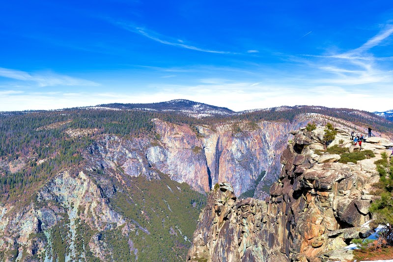
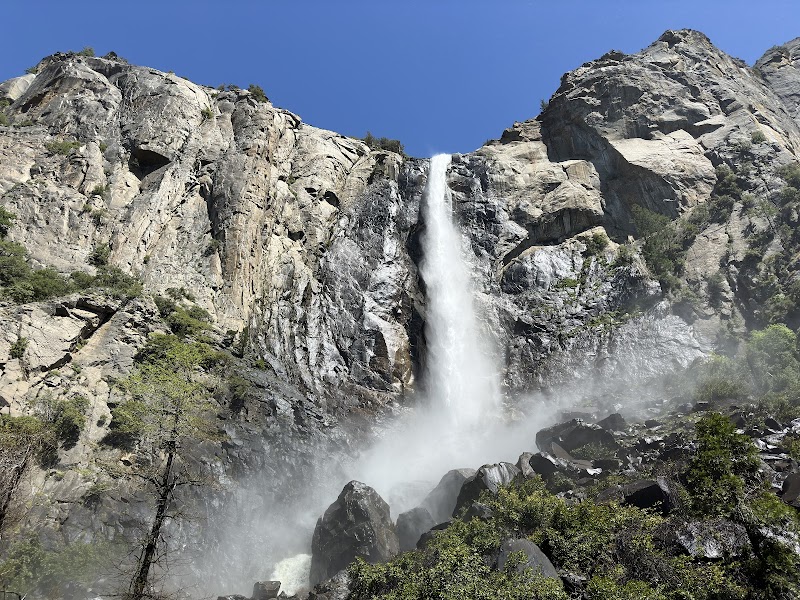
Hiking to Dewey Point is an iconic Yosemite experience that combines moderate physical activity with unparalleled views of the Sierra Nevada landscape. Located off Glacier Point Road, Dewey Point offers dramatic vistas of El Capitan, Yosemite Valley, and surrounding peaks. The hike is particularly beloved for its accessibility and diversity across seasons, serving as a snowshoeing trail in winter and a picturesque route in warmer months. This hike stands out for its broad appeal, encompassing both beginner and seasoned hikers aiming to witness Yosemite’s breathtaking beauty.
Hiking to Dewey Point via Glacier Point Road

Adventure Guide to Hiking to Dewey Point via Glacier Point Road

1

1. Location and Route Details

  • Details:

    Starting Point: McGurk Meadow Trailhead on Glacier Point Road.

  • Details:

    Distance: 7.8 miles roundtrip with a moderate elevation gain of approximately 800 feet.

  • Details:

    Trail Highlights: After passing through serene forests and open meadows, hikers are rewarded with Dewey Point’s stunning, unobstructed views of landmarks such as Bridalveil Fall and El Capitan. 2. Winter Appeal

  • Details:

    Dewey Point is a popular snowshoeing destination in winter. Special ski and snowshoe paths are maintained, with rentals available at Badger Pass Ski Area nearby.

  • Details:

    For winter adventurers, the snow-covered landscape adds an ethereal charm, amplifying the solitude and beauty of the ridge views. 3. Wildlife and Flora

  • Details:

    Along the trail, hikers may encounter mule deer, squirrels, or even a peregrine falcon soaring near the cliffs. During spring, wildflowers bloom along the meadows, creating idyllic settings for photography and picnicking.

2

Local Insights

  • Overview:

    Historically, Dewey Point was named after Admiral George Dewey to honor his naval victory in 1898. Glacier Point Road itself has played a pivotal role in opening the less-accessed regions of Yosemite National Park to visitors. Additionally, the ridgeline at Dewey Point gives hikers a unique sense of the granite expanse that characterizes Yosemite.

3

Visitor Tips

  • Details:

    Best Time to Visit: Spring for wildflowers, or winter for snowshoeing. Check road status during winter months, as Glacier Point Road closes after snowfall.

  • Details:

    What to Bring: Layered clothing, sturdy hiking boots, snacks, water, and a camera for the views! Winter visitors should bring snowshoes or rent on-site.

  • Details:

    Driving Directions: From Yosemite Valley, drive approximately 30 minutes (16 miles) via Wawona Road/Highway 41 to the Glacier Point Road turnoff.

Reviews

A
Arda Ünlü4 months ago

This is Stanford point. Another lookout on the Phono Trail. I liked this one better. Great place to camp. Stunning views. Do this hike instead of other popular ones.

K
Kay Moseleya year ago

Easy to moderate out and back trail.

J
James Lea year ago

An easy hike in the summer, a fun snowshoeing and skiing destination in the winter. Dewey Point offers another spectacular perspective on Yosemite Valley for minimal effort. My group and I backpacked here on 03/06/22. We took trail 18 (meadow). The trail is very well defined, though it does slightly detour through a small meadow as you close in towards where Trail 14 and Trail 18 join. There is new snow on the trail, many of the trees are covered in snow still. If you're seeking an enjoyable day trip, please be mindful of the weather and enjoy yourself.

J
Jaylee Moore2 years ago

Great destination! Enjoyed the open trail and peaceful outdoor atmosphere.

L
Lou Skunkape3 years ago

What a GREAT view!

Nearby Adventures

Bookable Experiences

E-Bike Through the Sierra: Fish Camp Trails and a Secret Waterfall3.65 mi
Fish Camp, California

E-Bike Through the Sierra: Fish Camp Trails and a Secret Waterfall

A concise guide to Tenaya at Yosemite’s e-bike rental in Fish Camp, covering easy-to-moderate trails, scenic Sierra National Forest views, and access to Tenaya’s secret waterfall.

3.65 miView Trips & Details →
E‑Bike Into the Sierra: A Guided Ride to Tenaya Falls3.70 mi
Fish Camp, California

E‑Bike Into the Sierra: A Guided Ride to Tenaya Falls

A guided, two-hour e‑bike mountain‑bike adventure in Fish Camp that covers a 5‑mile ride and a half‑mile hike to Tenaya Falls, operated by Tenaya at Yosemite.

3.70 miView Trips & Details →
Two Days at the Valley: Lodge-Side Sunrises and Sequoia Walks in Yosemite4.54 mi
San Bruno, California

Two Days at the Valley: Lodge-Side Sunrises and Sequoia Walks in Yosemite

A two-day option that places you at Yosemite Valley Lodge with guided hikes, unguided time to explore the Valley’s waterfalls and giant sequoias, and a return bus to San Francisco.

4.54 miView Trips & Details →
Under Yosemite’s Clear Mountain Sky: A 90‑Minute Naturalist‑Led Stargazing4.56 mi
Yosemite Valley, California

Under Yosemite’s Clear Mountain Sky: A 90‑Minute Naturalist‑Led Stargazing

A 1.5‑hour evening in Yosemite Valley led by a Yosemite naturalist that guides visitors of all ages to constellations and celestial sights.

4.56 miView Trips & Details →
Winter Quiet and Iconic Vistas: Semi‑guided Overnights in Yosemite Valley4.60 mi
Yosemite National Park, California

Winter Quiet and Iconic Vistas: Semi‑guided Overnights in Yosemite Valley

A 2+ day semi‑guided trip from San Francisco that arranges transportation and lodging so you can explore Yosemite’s Tunnel View, Half Dome views and valley trails at your own pace.

4.60 miView Trips & Details →
A Day to the Top: Half Dome Day Hike from Fresno7.02 mi
Fresno, California

A Day to the Top: Half Dome Day Hike from Fresno

A focused, single-day hiking experience to Half Dome near Fresno, California, run by Discovery Treks; this guide consolidates the verified basics and practical pointers.

7.02 miView Trips & Details →