Hiking the Goat Trail to Big Bluff in Buffalo National River, Arkansas
Adventure Destination

Hiking the Goat Trail to Big Bluff in Buffalo National River, Arkansas

Explore the Goat Trail to Big Bluff in Buffalo National River, Arkansas. Spanning 5.9 miles, this moderately challenging hike offers stunning vistas of the Ozark Mountains and Buffalo River. Ideal for adventure seekers, it's recommended to visit during spring or fall.

Hiking8.2/10Moderate
Photo Gallery

Category

Hiking

Typical Duration

2-4 hours

Difficulty

Moderate

About This Adventure Destination

Hiking the Goat Trail to Big Bluff is one of the most rewarding outdoor adventures in the Buffalo National River area of Arkansas. Located in the Ozark Mountains, this trail offers unparalleled views, unique geological features, and an impressive perspective on the river valley below. Big Bluff itself, towering at 500 feet above the Buffalo River, is recognized as one of the tallest bluffs along this scenic waterway, making it an iconic destination for hikers and nature enthusiasts.

Editorial Assessment

The Goat Trail to Big Bluff in Buffalo National River, Arkansas, offers breathtaking views and an exhilarating hiking experience along a narrow ledge with impressive rock formations. This natural landmark is a popular spot for outdoor enthusiasts due to its stunning scenery and the adventurous nature of the trail.
Hiking the Goat Trail to Big Bluff in Buffalo National River, Arkansas

Adventure Guide to Hiking the Goat Trail to Big Bluff in Buffalo National River, Arkansas

1

- Trailhead and Location: The hike begins at the Centerpoint Trailhead, easily accessible from Highway 43 near Ponca. The entire out-and-back trek is approximately 5.9 miles, with the Goat Trail being a narrow spur leading to Big Bluff. The trail features moderate difficulty due to elevation changes and rocky terrain.

  • Details:

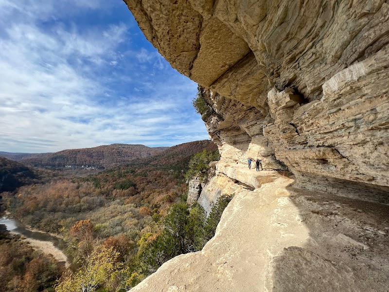
    Big Bluff’s Unique Features: Big Bluff is famed for its Goat Trail, a ledge with dramatic drop-offs offering breathtaking, panoramic views of the Buffalo River valley below. It’s a rare opportunity to experience the area's limestone bluffs up close. The ledge is about four feet wide in places, so caution is advised, especially for those sensitive to heights.

  • Details:

    Key Highlights Along the Way: Alongside scenic vistas, the trail is dotted with diverse flora and fauna. Depending on the season, you might spot wildflowers, white-tailed deer, or even Bald Eagles soaring overhead.

2

Local Insights

  • Overview:

    The name "Goat Trail" stems from its narrow paths resembling those trodden by goats, a nod to the area’s rugged terrain. Big Bluff has deep roots in local geology, created over millions of years of sedimentation and erosion. The Buffalo National River itself holds the title of America’s first designated national river, adding historical significance to your hike.

3

Visitor Tips

  • Details:

    Best Times to Visit: Late spring and early fall are ideal for mild weather and vibrant landscapes. Mornings are best for cooler temperatures and fewer crowds.

  • Details:

    What to Bring: Sturdy hiking boots, water, snacks, and a camera for capturing views. Avoid the trail in wet weather due to slippery conditions.

  • Details:

    Driving Directions: Centerpoint Trailhead is about a 45-minute drive south of Harrison, Arkansas via Highway 43.

Reviews

A
Autumn Burtonin the last week

Great destination! Enjoyed the open trail and peaceful outdoor atmosphere.

K
Kurtis Westphala month ago

Went here after a big rain, so there was water everywhere and the trails were super washed out. All the stuff done by the river is completely different, definitely made the bluff kinda sketchy. The very beginning of this trail is a huge hill, I would definitely rate this trail as moderate. The views are really good though

B
Bob Odom3 months ago

Such an awesome view of the Buffalo River and great hike for a novice hiker.

R
Ryan McClain2 months ago

A moderate hike down, more challenging on the way out but an incredible view with amazing Rick features and wind stressed trees. Not very little kid friendly and not good for dogs off leash. Parking is limited at the Compton trail head, maybe 20 vehicles.

J
JawShoeUh !3 months ago

I’m sure the trail is great.. however I was not expecting Google to drop me off at a campsite, where literally nobody had even heard of this trail, and the “maps” were so vague and not helpful, and I drove 4 hours to show up with no clue where I was going and the ranger station was closed, also I had zero cell service so it was even difficult to find my way back home. These issues seem all too frequent in Arkansas.. I would love to hike there but we can’t all be professional locals..

Nearby Adventures

Bookable Experiences

A One-Night RV Pause on the Edge of Boxley Valley3.73 mi
Kingston, Arkansas

A One-Night RV Pause on the Edge of Boxley Valley

A concise guide to a single-night RV stay at a campground near Boxley Valley—RV sites with hookups, picnic tables and fire rings, minutes from the Buffalo River and ATV access.

3.73 miView Trips & Details →
Shady Oak Camp B — Backside of Moonstruck Pond: Accessible seclusion for small groups3.96 mi
Kingston, Arkansas

Shady Oak Camp B — Backside of Moonstruck Pond: Accessible seclusion for small groups

A compact campsite at Moonstruck Pond that fits 2–3 tents and provides easy access to nearby recreational trails, with practical booking and rate details for families and small groups.

3.96 miView Trips & Details →
Cockatiel Meadow: A Quiet Canopy of Tents and Rock Firelight4.44 mi
Kingston, Arkansas

Cockatiel Meadow: A Quiet Canopy of Tents and Rock Firelight

Primitive tent camping at Cockatiel Camp C in Kingston — secluded, shaded sites with rock fire rings and options for easy or off-road access.

4.44 miView Trips & Details →
Morning Dew Camp A — A small red‑cliff campsite above Boxley with wide night skies5.39 mi
Kingston, Arkansas

Morning Dew Camp A — A small red‑cliff campsite above Boxley with wide night skies

A compact campsite in Boxley that accommodates 4–5 RVs or tents and is reached via roughly 1 mile of interior farm road; this guide compiles the onsite rules, access notes, and booking details you need.

5.39 miView Trips & Details →
Moonstruck Pond C — A shady, pondside campsite made for RVs and tents at Wilderness Rider Buffalo Ranch5.45 mi
Kingston, Arkansas

Moonstruck Pond C — A shady, pondside campsite made for RVs and tents at Wilderness Rider Buffalo Ranch

A concise guide to Moonstruck Pond C: a roomy, tree-canopied campsite beside a quiet pond with easy vehicle access and simple booking for stays of 1–10 nights.

5.45 miView Trips & Details →
Five Nights at Kingston’s Boxley Valley Campground: RV Spaces a Short Ride from the Buffalo River6.01 mi
Kingston, Arkansas

Five Nights at Kingston’s Boxley Valley Campground: RV Spaces a Short Ride from the Buffalo River

A five-night RV stay at a picturesque Kingston campground that lays out full hookups and campsite amenities while putting Buffalo River access, ATV riding, and hiking trails within easy reach.

6.01 miView Trips & Details →