Why Choose an Air Tour in Lake Ariel
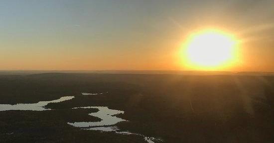
Raised just above treetops on a crisp morning, Lake Ariel folds beneath you like a hand-drawn map—rounded shorelines, peninsulas of spruce, and quiet inlets where loons and herons find refuge. The true draw of an air tour here is scale: what feels like an intimate neighborhood from shore becomes a landscape of patterns and passages from the air. Roads that unspool for miles become thin threads, and the surrounding Pocono ridgelines read like contour lines on a topographic sheet. Flying short stretches of the Pocono plateau reveals how lakes, wetlands, and rivers stitch together habitats that are otherwise hard to comprehend from land.
Seasonality shapes the aesthetic drama. Spring paints the shallows a luminous green as new growth edges the shoreline; summer compresses light into wide, sunlit plates that reflect cloud and canopy alike. Fall is the obvious headline—the region’s hardwoods ignite in bands of orange and crimson and the bays and marshes provide contrast like negative space on a painting. Winter is quieter and more architectural: stripped branches, frozen flats, and a different, more austere geometry to the countryside. For photographers and naturalists, these shifts are the point: each flight window offers a distinct palette and a different set of wildlife viewing opportunities.
Air tours here are more than sightseeing flights; they are practical connectors to the greater Pocono experience. A short charter can shuttle travelers to a remote lodge or offer a bird’s-eye reconnaissance before a backcountry fishing or hiking day. Pilots often double as local interpreters—experienced flyers know where seasonal concentrations of migrating waterfowl gather, where the state forests still show logging scars, and which ridgelines provide the cleanest vistas on hazy afternoons. For travelers who prefer to pair activities, a morning paddle around Lake Ariel followed by a late-afternoon flight makes for complementary perspectives: one on the water’s surface, the other above it. The intimacy of the aircraft matters—light planes and helicopters keep the experience personal, and operators tailor routes to weather, light, and the interests of passengers.
Practically, flights are short and focused—many sorties last 20–45 minutes—so they fit easily into day trips. That brevity is part of the appeal: you see a lot without committing a full day. But the brevity also means timing matters for light and weather; a half-hour at golden hour transforms the same shoreline that looked ordinary in midday into a silhouette of hills and mirrored bays. Finally, the aerial vantage encourages a different kind of conservation awareness: from above it’s easier to see how development, wetlands, and water quality interrelate, lending a clearer picture of the landscapes you explore on foot or by boat.
The topography around Lake Ariel—small lakes, marshy corridors, and low ridges—makes for compelling low-level flying where features are clearly visible and accessible within short flight times.
Air tours are seasonal and weather-dependent. Clear mornings and calm evenings produce the best visibility; strong crosswinds or low ceilings will abbreviate or reschedule flights.
Complementary activities like kayaking, fall foliage drives, and nearby mountain hiking pair naturally with an air tour to give both intimate ground-level and expansive aerial perspectives.