Crossing the Divide: A Full-Day Sprint Through Colorado’s High Country

Crossing the Divide: A Full-Day Sprint Through Colorado’s High Country

A compact, expertly guided day that packs geology, wildlife, and Breckenridge charm into one mountain-spanning loop.

Continue Reading

At dawn, Denver blinks awake behind a low bank of clouds while our van slides out of the city and into Clear Creek Canyon. The highway claws upward through a geologic storybook — red sandstone shelves near Golden, then granite and gneiss folding into grey-green pines. Wind stirs the trees like a conductor, and somewhere high above, a handful of bighorn sheep watch your progress with the unimpressed air of locals. This is not a day for slow wandering. It’s a curated, kinetic introduction to the Rockies: a rapid, sensory unraveling of geology, old mining towns, and the brittle clarity of high-altitude air.

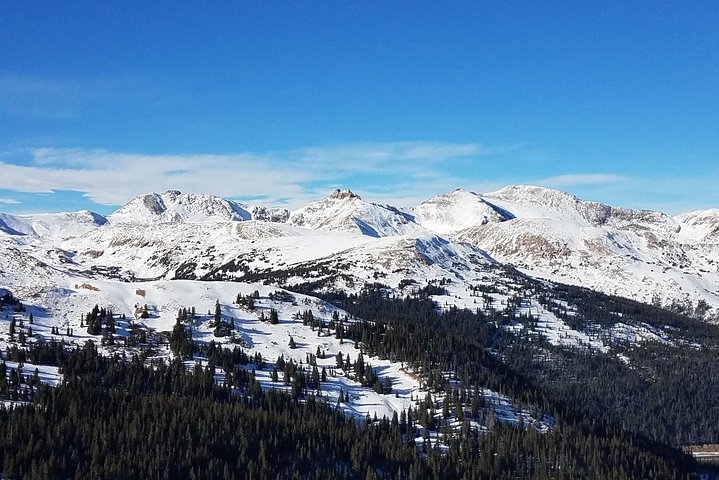
The Breckenridge Ultimate Full Day Mountain Tour is designed to show you as much of the high country as you can handle in one long, well-paced day. You’ll cross Clear Creek Canyon looking for sheep on cliffs, climb toward the Continental Divide where altitudes approach 12,000 feet, and take a short, sharp hike at Sapphire Point that rewards you with an unobstructed view across Lake Dillon and three distinct mountain ranges. There’s a pause for Breckenridge — its Main Street still lined with Victorian storefronts and the echo of 1859 mining claims — and an optional ride up the gondola (seasonal) to watch shadow and light move across the slopes.

Geology is the tour’s quiet protagonist. The route reveals the region’s violent past: uplift and erosion stacking plateaus and carving alpine bowls. The Continental Divide isn’t just a line on a map here; it’s a physical crest you’ll pass over, a place where drainage separates toward the Pacific or the Atlantic. That crest is the reason the views feel uncompromising — 360-degree exposures where you can see how the Rockies stitch themselves together. On clear days, the sense of scale is immediate and humbling.

Continental Divide

History and human stories thread through the landscape. Breckenridge’s boom-and-bust mining era shaped its streets, and the town wears that past comfortably — preserved façades house modern breweries and outfitters. Even the Eisenhower Tunnel carries a human tale: built to make travel under the Divide practical year-round, it’s the kind of engineering answer the mountains demand before giving up their winter secrets.

Culturally, the day is as much about small, local pleasures as alpine spectacle. Lunch on Main Street is intentionally unstructured — you can pick a tavern burger and a local brew or find a quieter café and people-watch. The town’s shops and galleries are a reminder that the Rockies are lived-in and loved, not just photographed.

Practically, this is a tour for people who want a lot without committing to technical mountaineering. The day stretches eight to nine hours (the operator lists 480–540 minutes), and the group size is capped at 12 — small enough that the guide can swap historical notes for route observations without shouting. There’s time for a short hike; expect rocky switchbacks, uneven footing, and thin air at higher elevations. Bring sun protection, layers, and a water system that encourages sipping, not gulping. Altitude will be the day’s most consistent companion: even energetic, fit travelers can feel winded at 10,000–12,000 feet.

Red Rocks Amphitheatre

The tour’s rhythm is practical and deliberate: scenic driving punctuated by photo stops, a gentle introductory walk at Sapphire Point, and a chance to stretch legs in Breckenridge. Wildlife sightings are common if you keep quiet and patient — marmots, elk, and the aforementioned bighorn sheep often appear along cliff and meadow edges. Because the tour prioritizes accessibility, there’s no skiing included; instead, you get context and multiple perspectives that make the ski towns make sense.

Why pick this over driving yourself? For one, the guide’s knowledge turns passing scenery into narrative: geology becomes readable, and the canyon’s human history gains texture. For another, you don’t have to hunt for parking or manage mountain driving on unfamiliar roads; the route includes the Eisenhower Tunnel and other stretches where local judgment keeps the day moving safely.

If you go: move slowly with your breath, don’t try to outrun altitude acclimatization, and treat the day as both scenic immersion and practical reconnaissance. This tour is a primer — it tells you where to return for longer hikes, which overlooks make the best sunrise photos, and which ski-town cafés are worth a detour. At dusk, as the van re-enters Denver, you’ll feel like you’ve run a condensed, brilliant semester in Colorado’s high-country essentials — leaving with a handful of real places to come back and stay.

Views on Loveland Pass

Practical snapshot: the tour is rated highly (average ~4.88 from 400 reviews), runs in small groups, and starts from Denver with prices from about $139 per person. It’s a day tailored for curious travelers who want the Rockies’ high points without committing to a multi-day trek.

Duration8–9 hours
Group Size1–12 Guests
LanguagesEnglish
Rating4.9 (456 reviews)
Plan your visit

Trail Wisdom

Acclimate Beforehand

If you’re coming from near sea level, spend a day in Denver or take it slow—altitude can make even short hikes feel hard.

Sip Frequently, Don’t Chug

Carry a 1–2L hydration system and take small, regular sips to manage altitude effects and dry mountain air.

Footwear Matters

Opt for sturdy trail shoes with good traction; short hikes include rocky, uneven surfaces and switchbacks.

Protect Your Skin and Eyes

Strong UV at altitude demands SPF 30+, a wide-brim hat or buff, and sunglasses with good UV protection.

Local Knowledge

Hidden Gems

  • Sapphire Point Overlook—short, dramatic hike with a broad view of Lake Dillon
  • Loveland Pass viewpoints—higher-altitude vistas and a chance to spot alpine flora and fauna

Wildlife

Bighorn Sheep, Elk

Conservation Note

Much of the route crosses National Forest and watershed lands—stay on trails, pack out trash, and avoid feeding wildlife to protect fragile alpine ecosystems.

Breckenridge began as an 1859 gold mining town; many Main Street buildings preserve Victorian architecture from that era.

Seasonal Guide

spring

Best for:Wildflowers emerging, Quieter trails, Lower shoulder-season crowds
Challenges:Unpredictable late snow, Mud and runoff, Variable road and trail conditions

Spring can be a study in contrasts—snow pockets remain at higher elevations while lower valleys green up; pack for changing conditions.

summer

Best for:Stable weather, Clear, long daylight, Gondola operations (seasonal)
Challenges:Afternoon thunderstorms, High UV exposure, Busy weekends in Breckenridge

Summer is the most straightforward time for clear views and reliable access, but plan for afternoon storms and busy towns.

fall

Best for:Golden aspens, Crisp air and crowds thinning, Excellent photography light
Challenges:Rapid temperature swings, Early snow possible at high elevations, Shorter daylight hours

Fall delivers vivid color and quieter trails, but bring warm layers—temperatures can drop quickly at 10,000+ feet.

winter

Best for:Snowy landscapes, Ski-resort backdrops, Possibility of seeing snowy wildlife tracks
Challenges:Icy roads and pass closures, Limited hiking window, Cold temps and high winds

Winter scenes are spectacular but logistics change—tunnel pass and road conditions matter; the tour emphasizes views, not skiing.

Photographer's Notes

Bring a wide-angle lens for sweeping lake-and-range shots at Sapphire Point and a 70–200mm or zoom for wildlife and ski-resort details; shoot early morning or late afternoon for the best light and use a polarizer to reduce glare on water and enhance sky contrast.

What to Bring

Layered clothing (base, insulating, shell)

Essential

Mountain weather changes fast; layers let you adapt to sun, wind, and sudden drops in temperature.

Hydration system (1–2L)

Essential

Regular sipping helps prevent altitude symptoms and keeps energy steady through the day.

Sturdy trail shoes

Essential

Short hikes include rocky, uneven terrain—grippy soles and ankle support make them more comfortable.

Sunscreen & polarized sunglasses

Essential

UV intensity is higher at altitude; protect skin and reduce glare on bright, snowy or reflective water surfaces.

Common Questions

How long is the tour and what time of day should I expect to return?

The tour runs approximately 8–9 hours (480–540 minutes); most departures return to Denver in the late afternoon or early evening depending on traffic and stops.

Is skiing included on this tour?

No — the itinerary focuses on scenic views, short hikes, and Breckenridge exploration rather than winter sports or lift tickets.

Will altitude affect me and how can I prepare?

Yes—altitude can cause shortness of breath, headache, or fatigue; hydrate well, avoid heavy alcohol before the day, and consider acclimating in Denver for 24 hours if you’re coming from low elevation.

What wildlife might I see?

Common sightings include bighorn sheep, elk, marmots, and various birds of prey; sightings aren’t guaranteed, so remain quiet and give animals space.

Are meals included?

Lunch in Breckenridge is on your own—this gives you freedom to choose from Main Street cafés, taverns, or quick bites depending on your appetite and time.

How many people are in a group and is the tour wheelchair accessible?

Groups are capped at 12 guests for an intimate experience; because the tour includes short hikes and uneven surfaces, it’s not fully wheelchair accessible.

What to Pack

Layers for temperature swings, hydration system (1–2L) for altitude, sturdy trail shoes for rocky hikes, sunscreen and sunglasses for strong UV

Did You Know

The Eisenhower Tunnel (I-70) is the highest vehicular tunnel in the United States, carrying traffic under the Continental Divide at approximately 11,158 feet.

Quick Travel Tips

1) Allow extra travel time for mountain traffic or road work; 2) Carry cash or card for parking/food in Breckenridge; 3) Check gondola hours if planning to ride; 4) Keep a light daypack to carry layers and water

Local Flavor

After a day on the pass, grab a beer at a local brewery on Breckenridge’s Main Street, try a hearty mountain bistro lunch, or pick up locally made chocolates or outdoor gear — the town mixes mining history with contemporary mountain culture.

Logistics Snapshot

Closest major airport: Denver International Airport (DEN); Driving distance from Denver to Breckenridge: ~80 miles (~1.5–2 hours each way); Cell service: patchy in high passes; Permits/passes: no special permits required but watch for paid parking in town and seasonal closures.

Sustainability Note

This route traverses National Forest and watershed areas—pack out everything, stay on designated trails, and avoid disturbing wildlife or delicate alpine vegetation.

Topics

Included

  • Transport by air-conditioned 12-15 passenger van
  • All taxes, fees and handling charges
  • Water refills, please bring a refillable water bottle for your own use
  • Professional driver/guide

Good to Know

  • Public transportation options are available nearby
  • Suitable for all physical fitness levels
  • Minimum numbers apply. If there are not enough passengers to meet requirements. In the rare event of this occurring, you will be offered an alternative tour or full refund
  • Only Children over 4years old permitted
  • Operates in all weather conditions unless unsafe driving conditions exist, so please dress comfortable outdoor appropriate clothes
  • Ski Gondola is available during the ski season and in the summer.