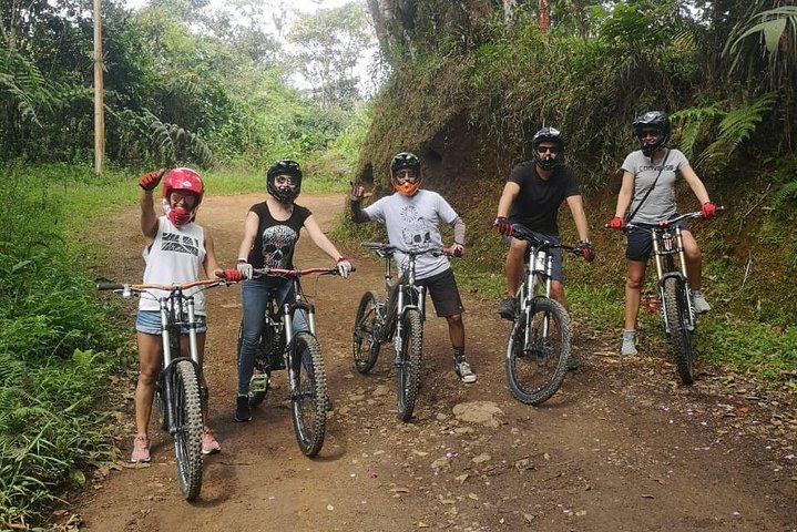
Gravity and Green: Riding the Western Andes into Cali

Gravity and Green: Riding the Western Andes into Cali

A cloud-forest descent from tea-covered highlands to the salsa city below

Continue Reading

Mist loosens its grip on the ridgeline as the Western Andes exhales. The cloud forest stirs—leaves bead silver, bromeliads blink awake, and the road unfurls like a ribbon pulled free. You swing a leg over the bike, clip in, and the mountain tips you forward, not with a shove but with a steady invitation. Gravity does the talking; the forest answers in birdsong and the rush of tires over wet grit. Cali waits below, sunlit and warm, but up here the air stays cool, scented with earth and tea.

This guided descent threads rural roads from the high flanks of the Cordillera Occidental down into Colombia’s third-largest city, stitching together microclimates as it goes. One moment you’re ghosting through fog—clouds teasing the canopy, moss-laced branches bowing over the lane—and the next you’re gliding past tea bushes combed into neat green lines across the slopes. It’s a rare sight in Colombia: tea, not coffee, thriving in the mist. You’ll stop for a simple picnic at the edge of these fields, where the cloud forest leans in to eavesdrop and thermals curl like breath over a warm mug.

The route is more glide than grind. Expect long, sustained downhills on a mix of paved rural byways and hardpack with patches of gravel, peppered with short rollers that wake the legs. It’s a ride for people who love corners—the kind that tighten their grip when the pavement shines, or open into sweeping arcs with big views. In the wet, the surface can turn slick; in the dry, dust rises and hangs. The mountain has moods, and it lets you know them.

Cali, the ride’s landing point, is salsa-sure and sun-hungry, perched in the broad Cauca Valley and bounded by three Andean ranges. Founded in 1536 by the conquistador Sebastián de Belalcázar, the city grew into a hub of sugarcane and culture, a place where rhythms from the Pacific met the highland breezes. The geology that shapes the day’s ride—the Western Andes catching Pacific moisture and wringing it into cloud—also shapes life here. Different thermal floors stack up like chapters: cool cloud forest above, temperate farms in the middle, and the warmth of Cali below. You’ll feel each shift with your skin.

Above the city, tea is a story in itself. The Bitaco Tea region near La Cumbre is Colombia’s only commercial-scale, high-mountain tea project, and it grows at the edge of a protected forest. Here, fog is not just scenery—it’s a collaborator, feeding the leaves and cooling the afternoons. When you pause for the picnic, it’s easy to see how humans fit gently into this landscape: narrow lanes brush past farm gates; dogs announce you, then lose interest; a farmer raises a hand as you ghost by. The forest peeks over every fence, curious.

As descents go, it’s accessible yet engaging: steady braking on long pitches, situational awareness in mist, and basic comfort on mixed surfaces. Figure on four to five hours door to door, depending on conditions and group pace, with plenty of time carved out for photos and that tea-side lunch. Your guide keeps the rhythm, pointing out corners that tighten, potholes that hide in shadow, and vistas that demand you stop and look. On clear days, the valley yawns open. On cloudy ones, the forest draws you close.

This is not a sterile, point-to-point exercise; it’s a moving conversation with a region. Birds slip across the road like punctuation—hummingbirds flicker, tanagers stitch color between branches. In the switchbacks, currents of cool air push at your jersey, testing your balance. Farther down, the road warms and straightens; papaya trees lean over fences, and small tiendas sell sodas and arepas hot off the griddle. After the ride, Cali’s energy takes over: music in the plazas, fruit vendors with lulo and maracuyá, and salsa that insists you move, even if you only tap a foot.

Planning is straightforward. Bring a shell for the high sections—cloud forest can cling to damp even on dry-season days—and gloves with good grip. Hydration matters more than the cool air suggests, so start topped up and keep sipping. If you’re newer to long descents, ask your guide to review braking technique; smooth, alternating pressure keeps rotors cool and your arms fresh. The route follows rural roads used by locals; ride predictably, yield to traffic, and give livestock wide berth.

Timing can change the character of the day. Morning starts often mean quieter lanes and clearer views before fog rebuilds; afternoons bring warmer air lower down and livelier tiendas. The Andes write their own forecast, so treat “dry season” as “probably” and “rainy season” as “prepare well.” Either way, the ride goes—just with a different personality. The mountain rarely says no; it simply asks for respect.

Back in Cali, it’s easy to fold the ride into a bigger story. Spend a late afternoon in San Antonio, the historic hillside neighborhood with cafes and colonial streets, or head to a salsa bar where the city’s pulse comes into focus. The same gravity that pulled you down the mountain will tug you onto the dance floor. The day doesn’t end at the trailhead; it changes modes.

What makes this descent special isn’t just its ease of access or the novelty of tea in a coffee country. It’s the way the route condenses Colombia’s variety into a single glide: cloud forest whispering at your shoulders; farms and fincas greeting you with a nod; city heat finally meeting your face like a welcome. It’s a ride that feels honest, shaped by terrain and weather and people—just you, a bike, and a mountain that knows exactly how to let you go.

Duration4–5 hours
Group Size1–10 Guests
LanguagesEnglish
Rating5.0 (6 reviews)

Not recommended for travelers with spinal injuries

Not recommended for pregnant travelers

Not recommended for travelers with poor cardiovascular health

Plan your visit

Trail Wisdom

Brake smart, not hard

Feather both brakes and alternate pressure on long pitches to avoid overheating rotors and hand fatigue.

Layers for the cloud forest

A light, packable rain shell keeps mist and wind off at higher elevations where temperatures drop quickly.

Eyes up in the corners

Moisture can slick the apex and hide gravel; scan ahead and set speed before entering turns.

Hydrate early, often

Cool air can mask sweat loss—aim to sip every 10–15 minutes to stay sharp on the descent.

Local Knowledge

Hidden Gems

  • Bitaco Tea region near La Cumbre for cloud-forest views and a rare Colombian tea landscape
  • Mirador at Kilómetro 18 along the old road for roadside arepas and cool mountain air

Wildlife

Hummingbirds in the cloud forest edges, Toucanets and tanagers along forested corridors

Conservation Note

Cloud forests are biodiversity hotspots and sensitive to erosion—ride on established roads, avoid skidding, and pack out everything. Respect gates and farm access; many lanes pass through private land.

Founded in 1536, Cali grew on trade routes linking the Andes and the Pacific. The Bitaco Tea project near La Cumbre is Colombia’s only commercial high-mountain tea operation.

Seasonal Guide

spring

Best for:Lush cloud-forest scenery, Cooler uphill temps
Challenges:Frequent showers, Slick surfaces

March–May is rainy in the Andes. Expect vivid greens, moody fog, and wet roads—beautiful but slower riding.

summer

Best for:Clear valley views, Drier road surfaces
Challenges:Midday heat at lower elevations, Afternoon winds

June–August trends drier, with crisper mornings up high and warmer finishes in Cali—prime for big panoramas.

fall

Best for:Quieter roads, Balanced temps
Challenges:Rain returns in Oct–Nov, Variable visibility

September starts stable, but October–November bring second rains. Flexible riders get rich color and fewer crowds.

winter

Best for:Consistent riding windows, Festive city atmosphere
Challenges:Passing mountain showers, Holiday traffic near towns

December–February often sees drier spells with quick showers. The city hums with events and warm evenings.

Photographer's Notes

Bring a circular polarizer to tame glare on wet leaves and deepen greens, and keep a microfiber cloth handy for misty lenses. In the fog, expose for midtones to preserve atmosphere; when the valley opens, stop for layered shots with riders in the foreground. A small dry bag or rain cover protects gear, and wide-angle lenses capture winding roads under the canopy.

What to Bring

Half-finger or full-finger bike gloves

Essential

Improves grip on wet levers and protects hands during long braking sections.

Lightweight waterproof shell

Essential

Cloud forest mist and showers are common; a shell keeps you warm and dry without bulk.

2-liter hydration system or bottles

Essential

Staying hydrated is key during sustained descents when cool air masks fluid loss.

○

Front and rear bike lights

Fog and low clouds can reduce visibility—small lights increase your margin of safety.

Common Questions

Do I need prior mountain biking experience?

Basic bike handling and comfort with braking on long descents are recommended. The route follows rural roads with mixed surfaces rather than technical singletrack.

Are bikes and helmets provided?

Most guided trips include bikes and helmets; confirm equipment details, sizes, and availability when booking.

What kind of terrain will we ride?

A mix of paved rural lanes, hardpack, and occasional gravel or potholes, with a net descent from cloud forest to the city.

Is lunch included?

A picnic stop by the tea fields is typically part of the experience—check your confirmation for specifics and dietary options.

How do we get to the start and back from the finish?

Trips usually include a vehicle shuttle from Cali to the highlands and a return or drop-off in the city; verify pickup points and times after booking.

What happens in bad weather?

Rain is common in the Andes. The ride generally proceeds with extra caution unless conditions are unsafe; your guide will make the call and adjust the route as needed.

What to Pack

Light rain shell for cloud-forest mist; Full-finger gloves for grip on wet levers; Sunscreen and sunglasses—UV is strong even in fog; Small cash for roadside snacks and tips

Did You Know

The Bitaco region near La Cumbre hosts Colombia’s only commercial tea plantation, producing high-mountain teas at the edge of a protected cloud forest.

Quick Travel Tips

Book a morning departure for quieter roads and steadier weather; Start hydrated and eat lightly—descending can mask energy dips; Expect cooler temps up high and hot sun in Cali—pack layers; Confirm hotel pickup and end-point drop-off to streamline your day

Local Flavor

Post-ride, head to San Antonio for coffee and views, then tuck into Pacific coast flavors—try encocado (coconut seafood) or aborrajados (cheese-stuffed plantains). For nightlife, La Topa Tolondra is a legendary salsa spot where locals and visitors mix. If you’re tea-curious, look for Bitaco varieties on local menus and in specialty shops.

Logistics Snapshot

Closest airport: Alfonso Bonilla Aragón International (CLO), ~30–45 minutes from central Cali. Typical trailhead: highlands near Kilómetro 18/La Cumbre, 45–90 minutes by shuttle. Cell service: spotty to none in the upper sections; better near towns. Permits: none required for rural roads—respect private property and follow guide instructions.

Sustainability Note

You’ll ride through sensitive cloud-forest corridors and working farms—stay on the route, skip skids that cause erosion, and carry a reusable bottle to cut single-use plastic. Support operators who contribute to local conservation in the Bitaco area.

Topics

Included

  • Transport
  • Healthy snack with vegetarian option
  • Full Face helmet and protective gloves
  • Use of bicycle
  • Coffee and/or Tea

Good to Know

  • Not recommended for travelers with spinal injuries
  • Not recommended for pregnant travelers
  • Not recommended for travelers with poor cardiovascular health
  • Suitable for all physical fitness levels