Majestic Peaks of Washington: Mount Adams
Adventure Destination

Majestic Peaks of Washington: Mount Adams

Explore Mount Adams in Washington, a challenging climb through stunning alpine scenery. At nearly 35 miles, the Round the Mountain Trail showcases diverse ecosystems. Best from late spring to early fall, it offers solitude and breathtaking views.

Climbing8.6/10Hard
Photo Gallery

Category

Climbing

Typical Duration

Half day

Difficulty

Hard

About This Adventure Destination

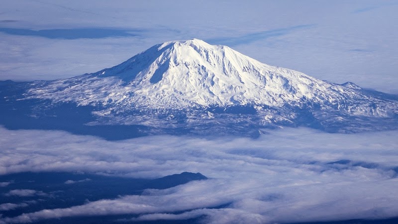
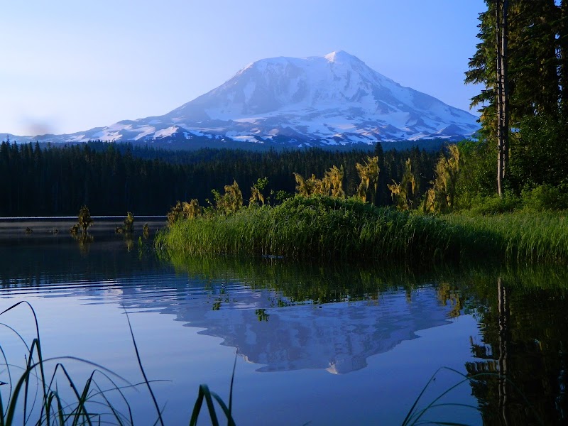
Mount Adams rises prominently in southern Washington, marking the second-highest peak in the state and an impressive feature within the Cascade Range. Towering at 12,281 feet, this massive stratovolcano stands east of Mount St. Helens and south of Mount Rainier, offering dramatic alpine views alongside glacial terrain rarely found at this elevation in the region. Its location within the vast Gifford Pinchot National Forest creates a striking contrast between snow-capped peaks and dense evergreen forests below.

The mountain’s surface is shaped by rugged lava flows, ancient glaciers, and sharp volcanic rock formations, making it a unique destination for those interested in geology and outdoor activities. The “Lunch Counter,” a broad lava rock field near 9,500 feet, is a popular resting spot during summit attempts and illustrates the volcanic origin clearly. Mount Adams holds cultural significance as well, known as Pahto or Klickitat by Native American tribes, with a portion of its eastern slopes belonging to the Yakima Nation. This rich human connection adds depth to its natural grandeur.

From gentle meadows bursting with wildflowers to icy crevasses and glaciated ridges, Mount Adams offers a diverse outdoor experience. Visitors can admire streams fed by melting glaciers, watch for wildlife such as mountain goats, and enjoy expansive views stretching into Oregon’s high desert and across the Cascade Crest on clear days. Its accessibility and relatively safe south side make it a sought-after destination for climbers ranging from beginners to seasoned hikers.

Mount Adams combines geological marvels, cultural history, and inviting wilderness into a truly memorable Pacific Northwest landmark, appealing to those who appreciate both natural beauty and physical challenge.


Editorial Assessment

Mount Adams is celebrated for its majestic beauty and diverse recreational offerings. Its allure lies in the varied outdoor activities it supports, from hiking and climbing to serene camping escapes. However, it is slightly overshadowed by some larger volcanic landmarks in terms of popularity.
Majestic Peaks of Washington: Mount Adams

Adventure Guide to Majestic Peaks of Washington: Mount Adams

1

1. South Climb Trailhead Summit Ascent

  • What makes it special: This trail is favored for its manageable slopes and absence of dangerous crevasses, making it ideal for beginner climbers.
  • Key features: Starting near 4,500 feet, the route passes the “Lunch Counter” lava field, Pikers Peak at around 11,600 feet, and the final summit at 12,281 feet. The descent offers thrilling glissading opportunities down snowfields.
  • Local insights: Early starts (around 3-4 a.m.) help avoid afternoon storms common at higher elevations. Some hikers spend a night camping at the Lunch Counter to break up the climb.
  • Visitor tips: Visit in late spring through early fall for best trail conditions. Pack crampons, ice axes, layered clothing, and plenty of water. Roads can be snow-covered, so check for access conditions before driving approximately 2.5 hours from Portland, Oregon, or 3 hours from Seattle, Washington.
2

2. Backcountry Camping at the Lunch Counter

  • What makes it special: This flat lava plateau at 9,500 feet offers a unique camping experience with panoramic mountain views and easy access to the summit trail.
  • Key features: Durable lava rock terrain reduces campsite erosion, making it sustainable for overnight stays. Clear nights reveal brilliant stars far from city lights.
  • Local insights: Permits are needed from the Forest Service. The site serves as a natural rest point for climbers tackling the summit over two days.
  • Visitor tips: Bring a reliable tent suited for windy conditions and cold nights. Water sources nearby are limited; carry extra water or a filter.
3

3. Wildlife Watching and Scenic Drives

  • What makes it special: Scenic routes around Mount Adams offer chances to spot mountain goats, deer, and various bird species, especially during dawn and dusk.
  • Key features: Along roads like the Cold Springs Campground access road, visitors can enjoy views of glaciers, forests, and meadows. Mount Adams’ visibility on clear days extends to places in Oregon, such as Hermiston Butte.
  • Local insights: The mountain’s visibility and natural surroundings attract photographers and nature lovers year-round. Indigenous stories highlight the cultural identity of the mountain area.
  • Visitor tips: Drive with caution on unpaved mountain roads. Carry binoculars and a camera with zoom for wildlife photos. Check weather forecasts and daylight hours for planning. Mount Adams offers varied outdoor adventures with breathtaking landscapes and cultural richness. Proper preparation ensures a safe and rewarding experience in this captivating corner of the Pacific Northwest.

Reviews

T
Tahalilin the last week

took me awhile but solid place

K
Kimberly Quiroza week ago

Great destination! Enjoyed the open trail and peaceful outdoor atmosphere.

A
A Google Usera week ago

MOUNTAIN DRY EARTH

D
Dane DeLuca2 weeks ago

The road is not terrible, washboardy in a few places. There is like 3 or 4 places where you need a bit of clearance and to go real slow (I did see some new Subaru s that looked stock out there). I slept in the parking lot to try and acclimate a bit. Started really late at 8am. I saw a Pine Martin about a mile in. Then the first stream comes in at like 2.6, the trial goes right through it and its super easy to cross. I stayed at glacier camp because I saw what looked like a big seasonal stream, there was and it was about 100 meters away. I was happy I stayed there and not lunch counter because you get good views of the surrounding mountains and the cool little valley. Also get to hear the water stream at night, its warmer, and made more sense for which route I was planning on taking. Woke up to a mountain goat at 6 am and started the climb. I really just wanted to get to pikers peak because I had no micro spikes or axe. I did find a stick around half way up that really helped. So I took the ridge all the way up. There is a metal cable that shows up every now and again on the floor woven between the rocks. This is the trail and you really should stay on it. Whoever did this I love you because it would have taken me so much longer with out it. There are like two or three streams after this to get water, you can't miss them. But this is only if you take the ridge trail. At Pikers I realized I could probably summit and headed over to the base of the switchbacks because I saw two people coming down. They confirmed I should be fine and to go to the Eastside and check out the glacier which i am really glad he told me to. So I floated on up and got there at 10am. I was trying to acclimate myself even more and it was a perfect day so I stayed till 3:15pm before heading down. Flew down to pikes peak and that's when I lost it. I was going to hang out there but I started to feel a bit sick and just wanted to get down. I thought it was the other ridge because I remember being way climbers left coming up. But realizing I was going into an abyss I quickly backtracked a bit a found the right place. So I am on the right ridge now for sure but I can't find the dam wire/trail. Now remember its literally an inch thick steel cable on the floor woven threw the rock sporadically on a steep mini bolder field. So its hard to lose but can be very difficult to find if you start off wrong like I did. This goes on for what seems like forever. 100% would not recommend if you aren't part mountain goat/great rock hopping skills/trail finding ability. You can take the wrong ridge very easily because they are so steep you cant see the bottoms. Was pretty dangerous so you really have to pay attention all the way down. Alot of loose rock, like every few steps. Then I realize that I am on the wrong ridge again, I mean fml right. Thank God I realized when I did so I didn't have to back track or do a sketchy traverse. Shortly after this I found the wire and I knew I made it. Stopped at one of the streams mentioned before and this is when I started to feel really sick. Guys if your sick don't feel like you can't lie down. I did for about 10 min which I think made me not throw up and felt so much better. Made it to camp 7:45pm and went right to bed. Woke up late felling better. Helped some people look for their car keys that they lost, bummer. Was visited by a humming bird at camp (didnt know they go up that high). All in all I think going up the ridge is the move it was pretty easy and I think way faster but not for everyone. Also maybe glizade down or just not get lost af but its easy to stray. The hardest part for me was coming down pikers but thats mostly because I was off trail/lost. Going up to Pikers was the second but honestly it looks alot worse than it is.

L
Lauren Liechty2 weeks ago

Gorgeous mountain. Taken on a hike here and put in situations like leader intentionally wandering near crevasse until I said something; taken a very winding difficult way up icy terrain (requiring poles and crampons and balance with pack and pickaxe, while others are just walking up the rocks on the side of the ice slope) and you're left wondering why; you watch them put too many drops of water cleaning solution into your only water bottles, which you asked if they would carry for you.

Nearby Adventures

Bookable Experiences

No bookable tours found for this category near Trout Lake, Washington

Try switching to "All Adventures" to see available outdoor expeditions.