Why the Delaware Water Gap Delivers for Air Activities
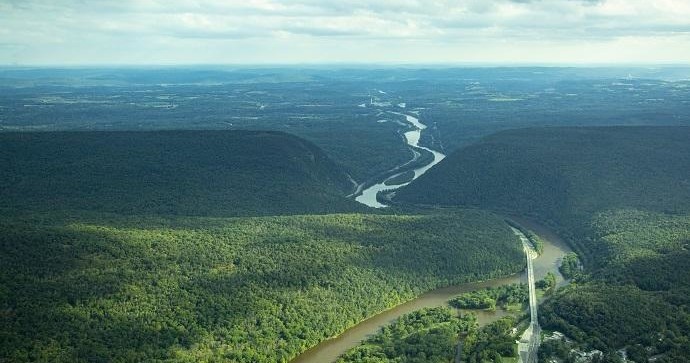
The Delaware Water Gap reads like an aerialist’s map: a deep river valley carved through a long, straight ridge; open farmfields that sit like mirrors beside the water; and a stitched patchwork of hardwood forest rising to the ridgecrest. For pilots, fliers, and balloonists the geography matters. The Kittatinny Ridge behaves predictably in the right weather—creating ridge lift and clean thermals that make short, thrilling ridge flights and safe sites for training and tandem flights. Dawn and dusk are the windows of choice: wind tends to calm, thermals are gentler, and the light softens the valley into layers of green and blue.
The human story is part of the appeal. Local operators run small fleets of light aircraft and hot-air balloons from fields tucked near East Stroudsburg and Brodheadsville; paragliding and hang gliding groups use ridge launch sites where the land drops away to the river. These are not high-altitude expeditions so much as intimate aerial encounters that foreground the river corridor, the exposed cliffs of the gap, and the rural communities knifed along the valley floor. The proximity to major population centers—New York and Philadelphia within a two-hour drive—means accessibility without the crowding of larger mountain ranges.
Beyond the mechanics of lift, the Gap delivers textures: the piano-key pattern of floodplain fields, the slow glinting of the Delaware River braided with shoals, and seasonally shifting forests. Spring brings fresh greens and rising thermals; late summer offers long, warm days for longer scenic flights; and fall provides a spectacle of foliage when flights feel like they’re sifting through fire. Operators and pilots here balance that spectacle with stewardship: the Gap is a national recreation area, and air activity intersects conservation rules, migratory-bird considerations, and FAA airspace — meaning your best day in the air is planned with both weather and regulation in mind.
Practical advantages are straightforward. Short flight windows, easy meet-up points near town, and a range of offerings—from introductory tandems to scenic airplane tours—make it a great place to try air activities for the first time. At the same time, ridge lines and thermal structure attract experienced paragliders and sailplane pilots who appreciate technical flying and cross-country possibilities. For travelers, an aerial trip here pairs naturally with paddling the Delaware, a ridgeline hike, or an afternoon at a riverside brewery—airtime becomes the connective tissue in a fuller, layered adventure.
Accessibility: Short drives from I‑80 and I‑287 put launch sites and small airfields within reach of regional airports and train stations, so visitors can combine a flight with a day of hiking or paddling.
Diversity of experiences: The corridor supports multiple air disciplines—hot-air balloon rides at dawn, tandem paragliding on ridge launches, scenic fixed‑wing flights for photography, and occasional ultralight operations from private fields.
Environmental and regulatory context: Because much of the area sits inside the Delaware Water Gap National Recreation Area, pilots and operators coordinate with park rules and FAA guidance. Drones and certain low-level operations are restricted—always check with the operator and park service before planning a flight.
Seasonal shaping: Spring and fall are the most stable times for ridge lift and thermal structure; summer afternoons can become turbulent, and winter flights are possible but limited by weather and shorter daylight.