Edge of the World: Riding and Photographing Dead Horse Point State Park

Edge of the World: Riding and Photographing Dead Horse Point State Park

Sunrise on the rim: mountain biking, e-bikes, and aerial views at one of Utah’s most dramatic overlooks

Continue Reading

You arrive before dawn, when the rim is a thin, silver line against a boiling sky. The wind here has a voice—sharp, impatient, like a packhorse nudging a column of riders onward. It teases the mesas and lifts the scent of sage and warmed sandstone. Below, the Colorado River carves a slow, stubborn coil, its green ribbon daring you to reckon with scale. From this vantage—two thousand feet above an entrenched meander—the land reads like a geologic ledger: layers of deep red, orange, and white stacked and tilted through deep time.

Dead Horse Point State Park is not a single trail or climb but a series of cinematic exposures: overlooks that make travel photography cliché for a reason, singletrack that unspools along the rim, and routes that carry you, fast and focused, into a sculpted desert. Established in the late 1950s to protect one of Utah’s most dramatic viewpoints, the park sits perched on the Island in the Sky plateau and looks directly across at Canyonlands National Park. The name—legend has it—comes from a corral once used by ranchers; a herd was rounded up and left on the point overnight, and some animals perished, leaving a story as stark as the cliffs.

Geologically, the park is a classroom in red-rock stratigraphy: Navajo sandstone, Cutler formations and the harder caps that hold mesas and spires in place. The Colorado River is the patient sculptor, incising meanders into the rock for millions of years until these dramatic ledges hung over the canyon. At elevation—roughly 6,000 feet—temperature swings are real: hot light on the canyon walls by day, a brittle clarity at night.

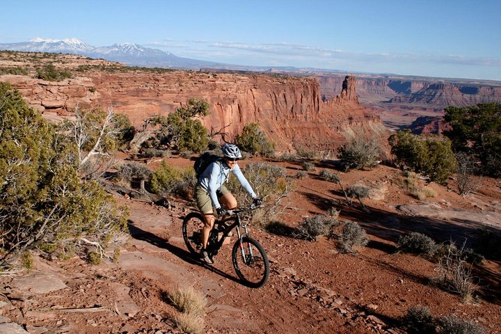
Why go? Because Dead Horse Point compresses the big-picture drama of the Colorado Plateau into a day’s worth of routes and exposures. For mountain bikers, this is legendary terrain. Intermediate guided rides through Dead Horse Point’s rolling singletrack reward steady pedaling with sweeping views: expect roughly 10 miles and 4–5 hours total for guided tours that include gear, helmets, park fees, and snacks. The trails are predominantly hard-packed desert singletrack with technical sections of slickrock, short punchy climbs, and exposed overlooks that reward both steady nerve and good bike handling.

If you prefer speed with a soundtrack of the wilderness, electric dirt bike tours along Shafer Trail let you pilot a quiet e-bike across slickrock and plateaus, cresting hills to capture sweeping views of the Colorado River and three parks in a single sweep. For a different kind of lift, plane and helicopter flights turn the mesas and potash ponds into abstract art: a 45-minute air tour paints the whole region in sweeping perspective, while sunset heli flights turn the cliffs incandescent and cinematic.

Photographers and sunrise chasers will find Dead Horse Point almost hypnotic. The park sits within easy reach of Moab, and many guided photography tours orbit this viewpoint at first light and again at sunset, pairing instruction on composition and exposure with the best local angles. Thelma and Louise Point—its fame cemented by a Hollywood frame—offers an iconic foreground for that wide-angle canyon grab shot, but better work can be done by walking the rim at dawn and isolating light on a single buttress or a band of shadow creeping up a canyon wall.

Practical edges: timing and conditions matter. Spring and fall are the sweet windows—milder temperatures, clearer air, and unforgettable light. Summer brings harsh sun, intense heat, and higher visitor counts; winter brings crisp clarity and icy ledges. Park access is straightforward from Moab, about a 35–45 minute drive down paved roads. There’s an entrance fee per vehicle; the park is open from sunrise to sunset and closes after dark for safety.

On the trails, sensible preparation makes everything more enjoyable. Hydration is nonnegotiable: surface water is absent, and shade is skirted by winds. Use grippy shoes and a mid-weight shell for the wind; layers are essential at elevation. For mountain biking, bring a tube, a pump or CO2, basic tools, and a willingness to push up short, steep stretches. Guided options remove gear stress—many operators include high-quality rental bikes, helmets, and park entry.

This is also a place where leave-no-trace matters: stay on established trails, respect fences and viewpoints, and keep a distance from cliff edges. The canyon edge is an honest boundary; a moment of distraction can have serious consequences.

There’s a subtle cultural layer to the place too. The landscape carries the imprint of Indigenous peoples who traversed these plateaus long before statehood, and later, the horses and ranchers whose lore gave the park its name. Moab—30–45 minutes away—offers the visitor services you’ll need: fuel, meals, bike shops, and guides who know when and where the light will be best.

When you leave, the image of the river winding through basalt and brick holds with you: a lesson in scale, patience, and the value of getting up early. Dead Horse Point isn’t just a viewpoint; it’s an invitation to move—by foot, by pedal, by machine—and to find your own cadence on the edge of the canyon.

If you want a concentrated encounter with the Colorado Plateau—big skies, raw stone, narrow trails and cinematic light—Dead Horse Point rewards attention. Whether you book a guided mountain bike loop, an e-bike sunset ride, or a photography-guided sunrise sweep, you’ll come away with both technical skills and a clearer sense of the geology and human stories that have made this spot one of Utah’s most photographed, and most felt, places.

Duration3–5 hours (guided mountain bike loop)
Plan your visit

Trail Wisdom

Start at sunrise or late afternoon

Light is softer and temperatures milder; sunrise reduces crowds and sunset turns canyon walls incandescent.

Hydrate heavily and carry extra water

There’s no potable water on trails—carry at least 2–3 liters per person for half-day outings and more in summer.

Use a guide for first-time riders

Guided mountain-bike and e-bike tours include bikes, helmets, and local knowledge of trail lines and safety.

Respect cliff edges and stay on marked trails

The overlooks drop sharply—keep distance, especially when composing photos or biking near the rim.

Local Knowledge

Hidden Gems

  • Walk the lesser-known trails off the main overlook to find quieter compositions and intimate sandstone textures
  • Near sunset, scope small fins and alcoves on the south rim for unique foregrounds away from Thelma & Louise Point

Wildlife

desert bighorn sheep, golden eagles and red-tailed hawks

Conservation Note

Stay on marked trails and pack out all waste; vehicle and air tours pay fees that fund park maintenance—support local operators who follow low-impact practices.

Ranching lore gave the park its name; the point was used historically for horse corrals and later protected as a state park in the 1950s.

Seasonal Guide

spring

Best for:cooler hiking and biking, wildflower highlights, clear air for photography
Challenges:windy afternoons, changeable temps, occasional flash floods in canyon areas

Spring brings comfortable temps and vivid light—ideal for hiking and early-season mountain biking, but plan for gusts and variable conditions.

summer

Best for:long daylight for air tours, warm evenings for sunset shoots, e-bike rides when temps are manageable
Challenges:high heat midday, more visitors, risk of dehydration

Summer offers long days and warm evenings—avoid midday heat, start early, and prioritize water and sun protection.

fall

Best for:stable weather and mild temps, excellent light for photography, prime mountain biking conditions
Challenges:cool nights, possible holiday crowds in October

Fall is the optimal season: pleasant riding temps, crisp air, and some of the best light of the year for wide-angle landscapes.

winter

Best for:clear, low-humidity vistas, dramatic light contrasts, fewer crowds
Challenges:icy ledges and cold winds, some road closures, shorter daylight hours

Winter delivers clarity and solitude; bring traction for icy sections and layer for wide temperature swings.

Photographer's Notes

Shoot wide at sunrise to capture the meander of the Colorado River; use a telephoto to compress layers at golden hour; bracket exposures for high contrast scenes and carry a neutral-density filter for long-exposure river shots in low light.

What to Bring

Hydration pack (2–3 L)

Essential

Keeps water accessible on long, exposed trails where shade and water are absent.

Helmet with good ventilation

Essential

Protects on varied terrain—mandatory for guided rides and safer near rim exposures.

All-weather layer and wind shell

Essential

Wind scours the mesa; a light shell blocks gusts and adds warmth at dawn or dusk.

Spare tube / mini-pump / multi-tool

Essential

Quick repair kit keeps you rolling on remote singletrack with limited cell service.

Common Questions

How far is Dead Horse Point from Moab?

The park is about a 30–45 minute drive from downtown Moab via paved roads—roughly 30 miles depending on your route.

Do I need a reservation to enter the park?

No reservation is typically required for day visits; standard vehicle day-use fees apply—check the park website for current rates and closures.

Are guided mountain bike tours appropriate for beginners?

Yes—many operators offer beginner and intermediate options; private or guided half-day tours tailor distance and difficulty to your group.

Can I fly a drone at Dead Horse Point?

Drones are generally prohibited in state and national parks; check current regulations before flying and respect park rules.

Is the park open year-round?

Yes, Dead Horse Point State Park is open year-round, but hours, conditions, and access can change in winter—confirm before you go.

What’s the best time of day to photograph the overlook?

Sunrise and sunset provide the most dramatic light—sunrise often has fewer crowds and clearer air, while sunset lights the canyon walls warmly.

What to Pack

Hydration pack (2–3L), layered wind shell, helmet (if biking), spare tube + mini-pump — for hydration, wind protection, safety, and basic repairs

Did You Know

Dead Horse Point’s overlook drops roughly 2,000 feet to the Colorado River and is one of the most photographed vistas in the American Southwest.

Quick Travel Tips

1) Start rides at dawn to avoid heat and crowds; 2) Fuel in Moab—services near the park are limited; 3) Carry cash or card for park entry fees; 4) Check local weather and road alerts before heading out.

Local Flavor

Moab’s community blends outdoor guiding, bike culture, and cowboy history; after a day on the rim, stop in town for locally roasted coffee, hearty Southwestern fare, and a chat with a bike mechanic about route beta.

Logistics Snapshot

Drive time: 35–45 min from Moab • Elevation: ~6,000 ft • Park hours: sunrise–sunset • Typical fee: vehicle day-use (check site for current pricing) • Cell: limited on rim

Sustainability Note

Respect fragile cryptobiotic soils—stay on trails, avoid skidding on slickrock, and support local guides who practice low-impact touring.

Topics