Quartz and Quiet: A Day in Shining Rock Wilderness

Quartz and Quiet: A Day in Shining Rock Wilderness

A six-hour guided day-hike through creekside forests to the gleaming quartz outcrops of Shining Rock

Continue Reading

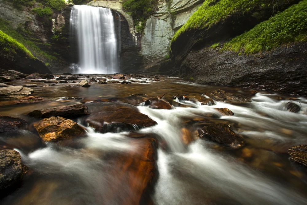
The day starts with the creek—cold, clear, and impatient, threading its way through a cathedral of hardwoods that filters the morning into green-gold bands. On the Shining Creek Trail, water is constant company: it snakes under roots, hurls itself over ledges, and occasionally pauses in a shallow pool that mirrors the forest. Your guide pauses too, not for breath but to point out the subtle signs most people miss—the way moss prefers the north-facing boulder, the silver of a salamander’s flank tucked into a seep, a quartz vein glinting like a quiet promise. By the time the forest opens and the white rock appears, you understand why this place is called Shining Rock.

This is not a postcard hike you’ll rush through to hit another checkbox. The Shining Rock Guided Tour—an approximately six-hour journey along the Shining Creek Trail from Big East Fork to Shining Rock Gap—wraps solitude, geology, and old-growth Appalachian character into a single day. Expect roughly 8–10 miles total and an elevation profile that leans steady: long climbs, steeper scrambles near the outcrops, with cumulative gain in the neighborhood of 1,500–1,900 feet depending on your exact route. Trail tread ranges from soft, root-felt soil to slabs of granite and occasional rocky switchbacks; the trail demands attention and rewards it with waterfalls, rim vistas and, at the top, the bleached quartz that gives the place its name.

Geologically, Shining Rock is a lesson in time told in stone. The white ledges are exposed veins of quartz—metamorphic scars left from ancient mountain-building events—set against weathered green and gray schist. Up close, the quartz carries tiny fractures filled with other minerals; from a distance it reads like a bleached band atop the ridge, reflecting late-day light. This geology shaped human stories here too. The Cherokee and earlier inhabitants knew the high country as a seasonal corridor; later, 19th- and early-20th-century logging and subsistence farming pushed in and out of these valleys, leaving a patchwork of regrowth. Today the Shining Rock Wilderness is held in trust within Pisgah National Forest, a protected remnant of the southern Blue Ridge.

Culture around these trails is small-scale and sincere. Guides who run private tours like this one are often locals who grew up crisscrossing the creeks; they’ll point out medicinal plants, explain the lifecycle of the hemlock and rhododendron, and tell stories about early fire suppression efforts that reshaped the forest’s understory. Your group will be small and private—ideal for a day of deliberate observation rather than a frantic summit selfie.

Practicalities matter here, and the guide-led format answers a lot of the logistics: navigation, pacing, and Leave No Trace practices are built into the itinerary. That said, there are smart preparation moves to make before you go. Start with footwear: stable, broken-in boots with good grip for wet granite and rooty climbs. Bring at least 2 liters of water and a filter or tablets if you’re used to refilling from creeks—while the water is clear, backcountry sanitation is paramount. Dress in layers; mountain weather is famously changeable, and the day can shift from sun to drizzle in twenty minutes. Trekking poles will take pressure off knees and help with creek crossings and steep sections.

Wildlife is quieter than on lowland trails but no less present—listen for the soft, hollow call of pileated woodpeckers, and keep an eye out for white-tailed deer at dawn or dusk. Black bears occur here too; your guide will brief the group on bear-aware behavior, food storage and how to avoid surprise encounters. Plants take center stage: in spring and early summer the trail corridor is edged with flame azalea, mountain laurel and carpets of foamflower; in fall, the ridgework explodes into color.

If you’re planning a visit, timing is everything. Spring brings swollen creeks and a chorus of salamanders but also nick-of-time mud; summer offers lush canopy shade but can be humid; fall is peak for the clearest views and hardwood color; winter strips the landscape to its bones and can deliver knee-deep snow and ice at the high points. A guided tour is flexible—the guide will tailor pace and route to conditions and guest fitness, but expect a steady six hours on your feet and come ready.

Why book this as a guided experience? Beyond safety, local guides translate a place’s subtle language—geology, botany, history—turning a long hike into a layered learning experience. And in a wilderness area where parking is limited and folktales are better shared around a creekside rock than scrolled on a phone, a guide gets you into the quiet parts: the loop that avoids crowded trailheads, the micro-waterfall where trout sometimes hold, the quartz outcrop that looks like a blank page just asking you to sit and read.

This is a hike for people who want to be present. It’s not the fastest way to a view, but it’s one of the most complete: the creek’s voice at your right, the set of the ridge ahead, the thrumming small lives underfoot and the long, pale line of quartz that marks the high place. Walk it deliberately, and you’ll come away with a clearer sense of how the Blue Ridge keeps its secrets—by shining them back at you only when you slow down enough to notice.

Duration5–7 hours
Group Size1–8 Guests
LanguagesEnglish

Not recommended for travelers with spinal injuries

Not recommended for pregnant travelers

Not recommended for travelers with poor cardiovascular health

Plan your visit

Trail Wisdom

Footing and Traction

Wear grippy, broken-in hiking boots—wet quartz and rooty climbs can be slippery.

Hydration & Filtration

Carry 2+ liters and a lightweight filter or tablets if you plan to refill from creeks.

Pace for Views

Allow time for stops—guides will point out geology and wildlife that reward a slow pace.

Bear-Aware Practices

Keep food sealed, make noise on brushy approaches, and follow your guide’s bear-safety briefing.

Local Knowledge

Hidden Gems

  • An upstream shallow pool on Shining Creek that reflects the canopy—great for a quiet lunch stop.
  • A small quartz alcove off the main gap that’s often overlooked but offers a sweeping southwest view.

Wildlife

Black bear, White-tailed deer

Conservation Note

Shining Rock Wilderness is managed as part of Pisgah National Forest—practice Leave No Trace, stay on durable surfaces, and pack out all waste to protect fragile high-elevation plants.

Shining Rock's quartz outcrops and high ridgelines were long-traveled corridors for Cherokee people; later logging and regrowth shaped the forest you see today.

Seasonal Guide

spring

Best for:Wildflowers, Waterfalls, Birding
Challenges:Muddy trails, Higher stream flows

Spring brings swollen creeks and a show of wildflowers—expect muddy sections and brisk water crossings after rain.

summer

Best for:Dense canopy shade, Stream dips, Long daylight
Challenges:Heat and humidity, Ticks

Summer offers lush green corridors and cooling creekside shade but pack insect protection and stay hydrated.

fall

Best for:Fall color, Clear vistas, Cooler hiking
Challenges:Shorter daylight, Variable temperatures

Autumn yields the clearest views and peak leaf color—book early for the best weekend spots.

winter

Best for:Crisp vistas, Snowy landscapes, Solitude
Challenges:Ice on quartz and rock, Limited services

Winter can be beautiful and quiet but brings ice hazards—microspikes and extra layers are essential.

Photographer's Notes

Shoot in early morning or late afternoon for the best light on quartz outcrops; use a polarizing filter to reduce glare on wet rock, and bring a mid-range zoom (24–70mm) for creek details and ridge panoramas—consider a small tripod for low-light creek shots.

What to Bring

Sturdy Hiking Boots

Essential

Necessary for traction on wet quartz slabs and uneven roots.

Daypack with 2–3L Hydration

Essential

Holds water, layers, snacks and first-aid for a full-day outing.

Lightweight Waterproof Layer

Essential

Mountain weather shifts quickly—pack a breathable rain shell.

○

Trekking Poles

Adds stability on creek crossings and steep sections; easy on knees.

Common Questions

How difficult is the Shining Rock Guided Tour?

The tour is moderate: expect 8–10 miles and about 1,500–1,900 feet of cumulative gain over varied terrain; guides set a pace suitable for most reasonably fit hikers.

Do I need previous hiking experience?

No technical experience is required, but you should be comfortable on uneven trails and able to hike several hours with breaks.

Are dogs allowed on this guided hike?

Most guided wilderness tours do not allow dogs due to wildlife concerns and group dynamics—confirm with the operator when booking.

Is there cell service on the trail?

Cell service is spotty to non-existent in much of the Shining Rock Wilderness; the guide will carry emergency communication devices.

When is the best time to see fall colors?

Mid-October is typically peak color on the higher ridgelines, but timing varies year to year—check local foliage reports.

Do I need a permit?

No special permit is required for day hiking in Pisgah National Forest, but parking can be limited and a wilderness fee or parking pass may be suggested by your guide—confirm details before arrival.

What to Pack

Hiking boots (traction on roots/rock), 2–3L water + filter (hydration and creek refills), layered waterproof jacket (variable weather), snacks/high-energy food (sustained effort)

Did You Know

Shining Rock is named for its white quartz outcrops that gleam on the ridge; these quartz veins are a visible remnant of the region’s complex geological history.

Quick Travel Tips

Fly into Asheville Regional (AVL); arrive early to secure limited trailhead parking; expect limited cell service—download maps; carry cash for small local purchases

Local Flavor

After your hike, drive back toward Asheville for craft beer and Appalachian fare—Tupelo Honey or Buxton Hall Barbecue are popular choices; for a quieter finish, stop in Canton or Sylva for a local diner and conversation about the day.

Logistics Snapshot

Closest airport: Asheville Regional (AVL); trailhead driving time from Asheville: ~45–60 minutes; cell service: spotty to none on most of the route; permits: no special permit for day hikes (confirm parking rules with operator).

Sustainability Note

This route traverses Shining Rock Wilderness—pack out all trash, avoid walking on exposed quartz ledges where alpine plants grow slowly, and follow your guide’s instructions to minimize impact.

Topics

Included

  • Binoculars
  • Trail map
  • Tree ID guide

Good to Know

  • Service animals allowed
  • Not recommended for travelers with spinal injuries
  • Not recommended for pregnant travelers
  • Not recommended for travelers with poor cardiovascular health
  • Travelers should have at least a moderate level of physical fitness