Walking the Edge: A Traveler’s Guide to Hawaii Volcanoes National Park

Walking the Edge: A Traveler’s Guide to Hawaii Volcanoes National Park

Step onto molten history—hikes, viewpoints, and practical tips for exploring Kīlauea and Mauna Loa safely and respectfully.

Continue Reading

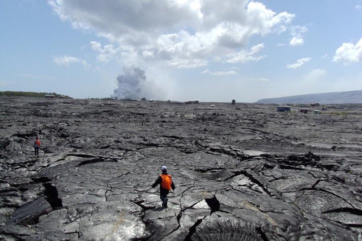
The morning opens like a page ripped from a geology textbook: steam plumes stitch the horizon, a cracked ribbon of black rock glints where older lava flows meet the new, and the air tastes faintly of sulfur as if the island itself is breathing. You step onto the Kīlauea Iki Trail and the earth beneath your boots tells a story of fire and patience—hardened pahoehoe, glassy pāhoehoe ropes, and the dusty, pumice-strewn floor of a crater that once roared. There is a rhythm here: the slow, patient work of molten rock reshaping the coastline, and the quicker cadence of your pulse as you crest a rim and the park unfolds below.

Hawaii Volcanoes National Park is the kind of place that asks you to pay attention. It protects two of the world’s most active volcanoes—Kīlauea and Mauna Loa—and more than 300,000 acres of lava fields, rainforests, and coastal cliffs on the Big Island of Hawaii. That geological diversity means the park is not one landscape but many: high, misty summits and steaming vents at 4,000 feet, stark, sun-baked deserts on the Kaʻū coastal plain, and emerald valleys where endemic plants push through fresh basalt like a slow green insistence.

To walk here is to trace the history of the island itself. Native Hawaiian stories are braided through the land—Pele, the volcano goddess, is more than myth; she is cultural context, a presence that informs how locals interact with eruptions and lava viewing. Geologically, the park is a live laboratory: Mauna Loa—the largest active volcano on Earth by volume—sits in silent magnitude, while Kīlauea’s frequent activity since the 20th century has made the park an international focal point for volcanologists.

A practical way to read the park is by its classic routes. The Kīlauea Iki Trail (about 4 miles round-trip, roughly 400 feet of elevation change) drops through a fern and ohia forest, passes the Thurston Lava Tube (a short, 0.4-mile walk), and crosses the crater floor. It’s tactile: you’ll feel the shift from soil to sharp lava glass to the fine, gritty ash that blankets the crater bottom. Devastation Trail is a short, accessible loop through a 1959 flow—less than a mile, but a clear lesson in how quickly a landscape can remake itself. For a different scale, drive Chain of Craters Road (about 19 miles to the coastline) to see where the island meets the Pacific in new-black cliffs and tumbled pahoehoe. These routes span microclimates; the summit can be fog-chilled and damp while the coast, miles away, is arid and sun-baked.

Beyond hiking, there are opportunities to extend the experience: guided ranger programs, interpretive centers that unpack eruption timelines, and—when conditions and regulations allow—lava viewing along designated coastal spots. Camping in the park is possible at established campgrounds and by permit in backcountry zones; stay vigilant about closures, permits, and safety briefings, because processes and access can change with eruptions.

The practicalities matter. Footwear should be sturdy and grippy—lava is sharp and unforgiving. Water is nonnegotiable: you’ll cross environments where shade disappears and wind can cut unexpectedly. A headlamp is useful for the Thurston Lava Tube, and layered clothing helps you adapt to summit chill and lower-elevation heat in a single day. Respect closures. Sulfur vents and skylights are dangerous; steam can be superheated and lava tube roofs are not stable where fresh flows are recent.

The park rewards slow attention. Stand at an overlook and watch the subtle glow of a night vent when conditions permit, or follow the trail where new life is everywhere trying to claim bare rock: amadouvier lichens, ohia trees that trap clouds with their leaves, and seabird colonies on cliffs below. Interpretive plaques tell timelines, but the land shows the processes in real time. Locals—rangers and island residents—remind visitors that this living landscape has its own logic and timing; patience and humility are part of the experience.

For photographers and curious travelers, the park offers dramatic contrast: steaming fissures against green forest, lava tubes carved like cathedrals, and coastal black sand where the ocean scours new cliff faces. Plan evenings for lower light and calmer air—sunsets over the Chain of Craters Road can silhouette basalt against a flush of magma-tinged sky.

If you go: start early to beat midday heat and spot more wildlife, carry a printed park map in case cell service is unreliable, check the National Park Service site for real-time alerts, and book accommodations in nearby Volcano Village or Hilo. And remember the etiquette here—stay on trails, do not collect rocks or cultural artifacts, and give the land room: vent areas, skylights, and fresh flows are closed for a reason.

At its best, a visit to Hawaii Volcanoes National Park alters your sense of time. You witness the doubled pace of life—slow geological work and the quick human heartbeat that accompanies discovery. It’s a place that insists on being read with all your senses: the smell of steam, the snap of crust underfoot, the hush of the forest. Walk with curiosity and respect, and the park will leave you with a clearer sense of how the planet remakes itself—and how small your footprints are in the wake of fire and patience.
Duration2–6 hours (varies by route)
Plan your visit

Trail Wisdom

Start early to change microclimates

Summit areas can be foggy and cool in the morning while lower trails get hot by midday—layer and begin hikes before 8 a.m.

Protect your feet from sharp lava

Use sturdy boots with thick soles; volcanic glass tears standard hiking shoes quickly.

Carry more water than you think

Dry coastal sections and the Kaʻū desert get hot and exposed—bring at least 2 liters for a half-day hike.

Headlamp for lava tubes

Thurston Lava Tube is dim and uneven—carry a headlamp or flashlight and watch your step.

Local Knowledge

Hidden Gems

  • Devastation Trail for accessible geology and quiet reflection
  • Kahuku Unit and coastal overlooks—less-visited, dramatic lava-sculpted shorelines

Wildlife

nēnē (Hawaiian goose), ʻio (Hawaiian hawk)

Conservation Note

Stay on designated trails and follow park guidance—fragile new soils and endemic plants are vulnerable to trampling and invasive species.

The park sits on land shaped by centuries of eruptions and is culturally significant to Native Hawaiians—Pele figures prominently in oral histories and place names.

Seasonal Guide

spring

Best for:wildflower blooms, cool summit hikes, fewer crowds
Challenges:intermittent rain, muddy trails

Spring brings milder weather and fresh green regrowth on older flows, but expect patchy rain at higher elevations.

summer

Best for:clear coastal vistas, extended daylight for longer routes, camping
Challenges:hot lowlands, vog (volcanic haze) can accumulate

Summer is generally drier and offers long days—stay hydrated and check vog conditions before setting out.

fall

Best for:stable weather, photography, fewer tourists than summer
Challenges:brief storm systems, variable temperatures

Fall often has stable conditions ideal for photography and crater-viewing; pack layers for temperature swings.

winter

Best for:dramatic cloudscapes, cool summit hikes, potentially fewer crowds
Challenges:cold, wet summit conditions, occasional closures due to storms

Winter can be wet and chilly at the summit—bring warm, waterproof layers and prepare for changing conditions.

Photographer's Notes

Golden hour softens basalt contrasts—shoot low to emphasize lava textures and use a telephoto for distant steam vents; at night, bring a tripod and long exposure settings to capture glow or stars over dark flows.

What to Bring

Sturdy hiking boots

Essential

Protects feet from sharp lava and uneven terrain.

2–3 liters of water

Essential

Hydration is critical—low-elevation sections can be hot and exposed.

Headlamp or flashlight

Essential

Needed for lava tubes and early-morning or evening light conditions.

Layered waterproof jacket

Essential

Summit areas are cool and wet—layers keep you comfortable across microclimates.

Common Questions

Do I need a permit to hike in Hawaii Volcanoes National Park?

Day hiking on established trails does not require a permit, but overnight backcountry camping requires a permit from the park; check the National Park Service website for current rules and reservations.

Can I see active lava flows?

Lava viewing depends on volcanic activity and park safety rules; when flows reach accessible coastal areas, the park and local authorities provide guidance—never approach flows outside designated viewing areas.

Is the Thurston Lava Tube safe to visit?

Yes—Thurston Lava Tube is a popular, generally safe stop, but it’s dark and uneven, so bring a light and watch for slippery or low sections.

What should I wear for hikes in the park?

Wear sturdy boots, sun protection, layered clothing for changing elevations, and a windproof or waterproof outer layer for summit conditions.

Are there guided tours available?

Ranger-led programs and private guided experiences are available seasonally; check the park calendar and local outfitters for current offerings and permits.

Where should I stay when visiting the park?

Nearby Volcano Village offers close access and lodging; Hilo and Kona provide more services and are 45–90 minutes by car depending on where you stay.

What to Pack

Water (2–3L), sturdy hiking boots for sharp lava, layered waterproof jacket for summit weather, headlamp for lava tubes

Did You Know

Hawaii Volcanoes National Park protects Kīlauea and Mauna Loa—two of the world’s most active volcanoes, and Kīlauea has had frequent eruptions in the modern era that reshaped the island’s coastline.

Quick Travel Tips

1) Check the NPS alerts for closures; 2) Start hikes early to avoid heat and vog; 3) Bring cash for small vendors in Volcano Village; 4) Respect cultural sites and do not take volcanic rocks.

Local Flavor

Stop in Volcano Village for locally roasted coffee, poke bowls, and Hawaiian plate lunches; visit the Hilo Farmers Market for tropical fruit and artisan crafts to connect with island foodways.

Logistics Snapshot

Park fees apply; watch for variable cell service; gas and supplies are limited inside the park area—fuel up in Hilo or Volcano Village; check eruption alerts before travel.

Sustainability Note

Stay on trails, pack out what you bring, and avoid removing rocks or cultural artifacts—small actions protect fragile new ecosystems and respect native cultural practices.

Topics